Boult-sur-Suippe
Boult-sur-Suippe ist eine französische Gemeinde mit 1.773 Einwohnern (Stand: 1. Januar 2019) im Département Marne in der Region Grand Est. Sie gehört zum Arrondissement Reims und zum Kanton Bourgogne. Die Einwohner werden Bouquins genannt.
| Boult-sur-Suippe | ||
|---|---|---|

|
| |
| Staat | Frankreich | |
| Region | Grand Est | |
| Département (Nr.) | Marne (51) | |
| Arrondissement | Reims | |
| Kanton | Bourgogne | |
| Gemeindeverband | Grand Reims | |
| Koordinaten | 49° 23′ N, 4° 4′ O | |
| Höhe | 66–116 m | |
| Fläche | 19,72 km² | |
| Einwohner | 1.773 (1. Januar 2019) | |
| Bevölkerungsdichte | 90 Einw./km² | |
| Postleitzahl | 51110 | |
| INSEE-Code | 51074 | |
| Website | https://www.boultsursuippe.fr/ | |
 Rathaus von Boult-sur-Suippe | ||

Geographie
Boult-sur-Suippe liegt etwa 15 Kilometer nordnordöstlich von Reims an der Suippe. Umgeben wird Boult-sur-Suippe von den Nachbargemeinden Houdilcourt im Norden und Nordwesten, Sault-Saint-Remy im Norden, Roizy im Norden und Nordosten, L’Écaille im Nordosten, Bazancourt im Osten, Pomacle im Süden, Bourgogne-Fresne im Südwesten sowie Saint-Étienne-sur-Suippe im Westen.
Bevölkerungsentwicklung
| Jahr | 1962 | 1968 | 1975 | 1982 | 1990 | 1999 | 2006 | 2012 | 2018 |
| Einwohner | 840 | 974 | 938 | 899 | 1361 | 1353 | 1436 | 1688 | 1710 |
| Quellen: Cassini und INSEE | |||||||||
Sehenswürdigkeiten
- Kirche Sainte-Croix aus dem 12./13. Jahrhundert, seit 1920 Monument historique
- Kapelle Notre-Dame-du-Bon-Secours aus dem Jahre 1537, 2002 wieder errichtet
- Weberei
- Mahnmal der Toten
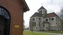
Kirche Sainte-Croix mit der Kapelle Notre-Dame-du-Bon-Secours im Vordergrund
This article is issued from Wikipedia. The text is licensed under Creative Commons - Attribution - Sharealike. The authors of the article are listed here. Additional terms may apply for the media files, click on images to show image meta data.