Saint-Floxel
Saint-Floxel ist eine französische Gemeinde mit 494 Einwohnern (Stand: 1. Januar 2019) im Département Manche in der Region Normandie. Sie gehört zum Arrondissement Cherbourg und zum Kanton Valognes.
| Saint-Floxel | ||
|---|---|---|
| ||
| Staat | Frankreich | |
| Region | Normandie | |
| Département (Nr.) | Manche (50) | |
| Arrondissement | Cherbourg | |
| Kanton | Valognes | |
| Gemeindeverband | Cotentin | |
| Koordinaten | 49° 30′ N, 1° 21′ W | |
| Höhe | 15–73 m | |
| Fläche | 8,52 km² | |
| Einwohner | 494 (1. Januar 2019) | |
| Bevölkerungsdichte | 58 Einw./km² | |
| Postleitzahl | 50310 | |
| INSEE-Code | 50467 | |
 Mairie Saint-Floxel | ||

Lage
Sie liegt auf der Halbinsel Cotentin. Nachbargemeinden sind Montebourg im Nordwesten, Vaudreville im Norden, Ozeville im Nordosten, Fontenay-sur-Mer im Osten, Saint-Marcouf und Émondeville im Südosten, Joganville im Süden, Écausseville und Éroudeville im Südwesten.
Bevölkerungsentwicklung
| Jahr | 1962 | 1968 | 1975 | 1982 | 1990 | 1999 | 2008 | 2018 |
|---|---|---|---|---|---|---|---|---|
| Einwohner | 314 | 325 | 293 | 326 | 348 | 417 | 439 | 493 |
Sehenswürdigkeiten
- Kirche Saint-Floxel
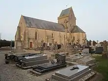
Kirche Saint-Floxel
This article is issued from Wikipedia. The text is licensed under Creative Commons - Attribution - Sharealike. The authors of the article are listed here. Additional terms may apply for the media files, click on images to show image meta data.