Montfarville
Montfarville ist eine französische Gemeinde mit 802 Einwohnern (Stand: 1. Januar 2019) im Département Manche in der Region Normandie. Sie gehört zum Arrondissement Cherbourg und zum Kanton Val-de-Saire.
| Montfarville | ||
|---|---|---|
| ||
| Staat | Frankreich | |
| Region | Normandie | |
| Département (Nr.) | Manche (50) | |
| Arrondissement | Cherbourg | |
| Kanton | Val-de-Saire | |
| Gemeindeverband | Cotentin | |
| Koordinaten | 49° 39′ N, 1° 16′ W | |
| Höhe | 0–28 m | |
| Fläche | 5,49 km² | |
| Einwohner | 802 (1. Januar 2019) | |
| Bevölkerungsdichte | 146 Einw./km² | |
| Postleitzahl | 50760 | |
| INSEE-Code | 50342 | |
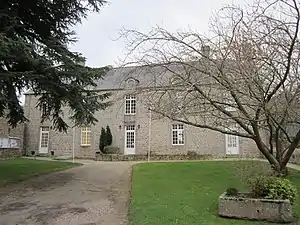 Mairie Montfarville | ||

Geographie
Montfarville liegt in der Landschaft Val de Saire auf der Halbinsel Cotentin an der Küste des Ärmelkanals. Nachbargemeinden sind Gatteville-le-Phare und Barfleur im Norden, Réville und Anneville-en-Saire im Süden sowie Valcanville und Sainte-Geneviève im Westen.
Bevölkerungsentwicklung
| Jahr | 1962 | 1968 | 1975 | 1982 | 1990 | 1999 | 2008 | 2018 |
|---|---|---|---|---|---|---|---|---|
| Einwohner | 901 | 914 | 862 | 763 | 866 | 860 | 805 | 805 |
Sehenswürdigkeiten
- Kirche Notre-Dame, Monument historique seit 1994
- ehemalige Mairie
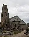 Kirche Notre-Dame
 ehemalige Mairie
This article is issued from Wikipedia. The text is licensed under Creative Commons - Attribution - Sharealike. The authors of the article are listed here. Additional terms may apply for the media files, click on images to show image meta data.