Valcanville
Valcanville ist eine französische Gemeinde mit 402 Einwohnern (Stand: 1. Januar 2019) im Département Manche in der Region Normandie. Sie gehört zum Arrondissement Cherbourg und zum Kanton Val-de-Saire.
| Valcanville | ||
|---|---|---|
.svg.png.webp)
|
| |
| Staat | Frankreich | |
| Region | Normandie | |
| Département (Nr.) | Manche (50) | |
| Arrondissement | Cherbourg | |
| Kanton | Val-de-Saire | |
| Gemeindeverband | Cotentin | |
| Koordinaten | 49° 39′ N, 1° 20′ W | |
| Höhe | 8–86 m | |
| Fläche | 6,60 km² | |
| Einwohner | 402 (1. Januar 2019) | |
| Bevölkerungsdichte | 61 Einw./km² | |
| Postleitzahl | 50760 | |
| INSEE-Code | 50613 | |
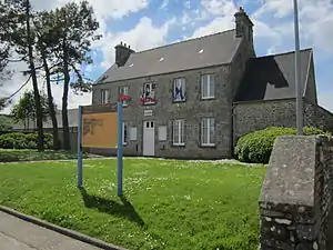 Mairie Valcanville | ||

Geographie
Die Gemeinde liegt in der Landschaft Val de Saire auf der Halbinsel Cotentin. Sie grenzt im Nordwesten an Clitourps und Tocqueville, im Norden an Sainte-Geneviève, im Nordosten an Montfarville, im Südosten an Anneville-en-Saire, im Süden an Le Vicel, im Südwesten an Le Vast und im Westen an Canteloup.
Bevölkerungsentwicklung
| Jahr | 1962 | 1968 | 1975 | 1982 | 1990 | 1999 | 2008 | 2018 |
|---|---|---|---|---|---|---|---|---|
| Einwohner | 465 | 450 | 421 | 402 | 421 | 387 | 368 | 409 |
Sehenswürdigkeiten
- Kirche Notre-Dame
- Oratorium Notre-Dame de la Délivrance
.JPG.webp)
Kirche Notre-Dame
.jpg.webp)
Oratorium
This article is issued from Wikipedia. The text is licensed under Creative Commons - Attribution - Sharealike. The authors of the article are listed here. Additional terms may apply for the media files, click on images to show image meta data.