Saint-Bonnet-les-Oules
Saint-Bonnet-les-Oules ist eine französische Gemeinde mit 1.669 Einwohnern (Stand: 1. Januar 2019) im Département Loire in der Region Auvergne-Rhône-Alpes. Saint-Bonnet-les-Oules gehört zum Arrondissement Montbrison und zum Kanton Andrézieux-Bouthéon (bis 2015: Kanton Saint-Galmier).
| Saint-Bonnet-les-Oules | ||
|---|---|---|
.svg.png.webp)
|
| |
| Staat | Frankreich | |
| Region | Auvergne-Rhône-Alpes | |
| Département (Nr.) | Loire (42) | |
| Arrondissement | Montbrison | |
| Kanton | Andrézieux-Bouthéon | |
| Gemeindeverband | Saint-Étienne Métropole | |
| Koordinaten | 45° 33′ N, 4° 20′ O | |
| Höhe | 392–586 m | |
| Fläche | 12,42 km² | |
| Einwohner | 1.669 (1. Januar 2019) | |
| Bevölkerungsdichte | 134 Einw./km² | |
| Postleitzahl | 42330 | |
| INSEE-Code | 42206 | |
| Website | http://www.saint-bonnet-les-oules.fr/ | |
 Rathaus (Mairie) von Saint-Bonnet-les-Oules | ||

Geografie
Saint-Bonnet-les-Oules liegt etwa zwölf Kilometer nordnordwestlich von Saint-Étienne in der historischen Landschaft Forez. Umgeben wird Saint-Bonnet-les-Oules von den Nachbargemeinden Chambœuf im Norden, Aveizieux im Nordosten, Saint-Héand im Osten, La Fouillouse im Süden, Andrézieux-Bouthéon im Westen und Südwesten sowie Veauche im Nordwesten.
Bevölkerungsentwicklung
| Jahr | 1962 | 1968 | 1975 | 1982 | 1990 | 1999 | 2006 | 2017 |
|---|---|---|---|---|---|---|---|---|
| Einwohner | 429 | 416 | 618 | 889 | 982 | 1257 | 1425 | 1638 |
| Quellen: Cassini und INSEE | ||||||||
Sehenswürdigkeiten
- Kirche Saint-Bonnet aus dem 13. Jahrhundert
- zwei Schlösser
Weblinks
Commons: Saint-Bonnet-les-Oules – Sammlung von Bildern, Videos und Audiodateien
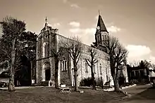
Kirche Saint-Bonnet
This article is issued from Wikipedia. The text is licensed under Creative Commons - Attribution - Sharealike. The authors of the article are listed here. Additional terms may apply for the media files, click on images to show image meta data.