L’Hôpital-sous-Rochefort
L’Hôpital-sous-Rochefort ist eine französische Gemeinde im Département Loire in der Region Auvergne-Rhône-Alpes. Sie gehört zum Arrondissement Montbrison und Kanton Boën-sur-Lignon.
| L’Hôpital-sous-Rochefort | ||
|---|---|---|
.svg.png.webp)
|
| |
| Staat | Frankreich | |
| Region | Auvergne-Rhône-Alpes | |
| Département (Nr.) | Loire (42) | |
| Arrondissement | Montbrison | |
| Kanton | Boën-sur-Lignon | |
| Gemeindeverband | Loire Forez | |
| Koordinaten | 45° 46′ N, 3° 56′ O | |
| Höhe | 411–578 m | |
| Fläche | 1,10 km² | |
| Einwohner | 109 (1. Januar 2019) | |
| Bevölkerungsdichte | 99 Einw./km² | |
| Postleitzahl | 42130 | |
| INSEE-Code | 42109 | |

Geografie, Infrastruktur
L’Hôpital-sous-Rochefort grenzt an Sainte-Sixte, Débats-Rivière-d’Orpra und Saint-Laurent-Rochefort. Die Route nationale 89 tangiert die Ortschaft.
Bevölkerungsentwicklung
| Jahr | 1962 | 1968 | 1975 | 1982 | 1990 | 1999 | 2008 | 2017 |
|---|---|---|---|---|---|---|---|---|
| Einwohner | 222 | 244 | 132 | 132 | 124 | 109 | 108 | 110 |
| Quellen: Cassini und INSEE | ||||||||
Sehenswürdigkeiten
- Kirche Notre-Dame, Monument historique
- Das Wohngebäude „Maison Coupat“
- Propstei
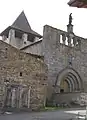 Kirche Notre-Dame
 Maison Coupat
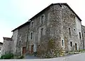 Propstei
Weblinks
Commons: L'Hôpital-sous-Rochefort – Sammlung von Bildern, Videos und Audiodateien
This article is issued from Wikipedia. The text is licensed under Creative Commons - Attribution - Sharealike. The authors of the article are listed here. Additional terms may apply for the media files, click on images to show image meta data.