Sainpuits
Sainpuits ist eine französische Gemeinde mit 312 Einwohnern (Stand: 1. Januar 2019) im Département Yonne in der Region Bourgogne-Franche-Comté (vor 2016 Bourgogne); sie gehört zum Arrondissement Auxerre und zum Kanton Vincelles (bis 2015 Saint-Sauveur-en-Puisaye). Die Einwohner werden Sainépuisiens genannt.
| Sainpuits | ||
|---|---|---|
| ||
| Staat | Frankreich | |
| Region | Bourgogne-Franche-Comté | |
| Département (Nr.) | Yonne (89) | |
| Arrondissement | Auxerre | |
| Kanton | Vincelles | |
| Gemeindeverband | Puisaye-Forterre | |
| Koordinaten | 47° 31′ N, 3° 15′ O | |
| Höhe | 217–306 m | |
| Fläche | 22,82 km² | |
| Einwohner | 312 (1. Januar 2019) | |
| Bevölkerungsdichte | 14 Einw./km² | |
| Postleitzahl | 89520 | |
| INSEE-Code | 89331 | |
| Website | https://sainpuits.fr/ | |
-mairie-02.JPG.webp) Rathaus (Mairie) und Schule von Sainpuits | ||

Geographie
Sainpuits liegt etwa 40 Kilometer südwestlich von Auxerre. Umgeben wird Sainpuits von den Nachbargemeinden Treigny-Perreuse-Sainte-Colombe mit Treigny im Norden und Nordwesten, Lainsecq im Norden und Nordosten, Étais-la-Sauvin im Osten, Entrains-sur-Nohain im Westen und Südwesten sowie Bouhy im Westen und Südwesten.
Bevölkerungsentwicklung
| Jahr | 1962 | 1968 | 1975 | 1982 | 1990 | 1999 | 2006 | 2013 |
| Einwohner | 513 | 574 | 421 | 352 | 321 | 299 | 326 | 318 |
| Quelle: Cassini und INSEE | ||||||||
Sehenswürdigkeiten
- Kirche Sainte-Marie-Madeleine aus dem 12. Jahrhundert, Monument historique
- Kapelle Notre-Dame-de-Lorette, seit 1987 Monument historique
- Schloss Les Barres, seit 1997 Monument historique
- Schloss Flacy
 Kirche Sainte-Marie-Madeleine
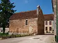 Kapelle Notre-Dame-de-Lorette
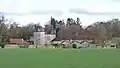 Schloss Les Barres
 Schloss Flacy
This article is issued from Wikipedia. The text is licensed under Creative Commons - Attribution - Sharealike. The authors of the article are listed here. Additional terms may apply for the media files, click on images to show image meta data.