Coulangeron
Coulangeron ist eine französische Gemeinde mit 217 Einwohnern (Stand: 1. Januar 2019) im Département Yonne in der Region Bourgogne-Franche-Comté (vor 2016 Bourgogne); sie gehört zum Arrondissement Auxerre und zum Kanton Vincelles (bis 2015 Coulanges-la-Vineuse).
| Coulangeron | ||
|---|---|---|
| ||
| Staat | Frankreich | |
| Region | Bourgogne-Franche-Comté | |
| Département (Nr.) | Yonne (89) | |
| Arrondissement | Auxerre | |
| Kanton | Vincelles | |
| Gemeindeverband | Puisaye-Forterre | |
| Koordinaten | 47° 41′ N, 3° 28′ O | |
| Höhe | 195–346 m | |
| Fläche | 8,57 km² | |
| Einwohner | 217 (1. Januar 2019) | |
| Bevölkerungsdichte | 25 Einw./km² | |
| Postleitzahl | 89580 | |
| INSEE-Code | 89117 | |
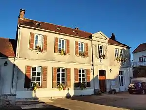 Rathaus (Mairie) von Coulangeron | ||

Geographie
Coulangeron liegt etwa 15 Kilometer südsüdwestlich von Auxerre. Umgeben wird Coulangeron von den Nachbargemeinden Escamps im Norden und Nordosten, Merry-Sec im Süden und Osten, Ouanne im Westen und Südwesten sowie Diges im Nordwesten.
Bevölkerungsentwicklung
| Jahr | 1962 | 1968 | 1975 | 1982 | 1990 | 1999 | 2006 | 2013 |
| Einwohner | 152 | 132 | 108 | 138 | 134 | 167 | 193 | 209 |
| Quelle: Cassini und INSEE | ||||||||
Sehenswürdigkeiten
- Kirche Saint-Charles
- Schloss Coulangeron
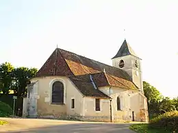
Kirche Saint-Charles
This article is issued from Wikipedia. The text is licensed under Creative Commons - Attribution - Sharealike. The authors of the article are listed here. Additional terms may apply for the media files, click on images to show image meta data.