Sérézin-de-la-Tour
Sérézin-de-la-Tour ist eine französische Gemeinde mit 1.106 Einwohnern (Stand: 1. Januar 2019) im Département Isère in der Region Auvergne-Rhône-Alpes. Sérézin-de-la-Tour gehört zum Arrondissement La Tour-du-Pin und zum Kanton Bourgoin-Jallieu (bis 2015: Kanton Bourgoin-Jallieu-Sud). Die Einwohner nennen sich selbst Saint-Albanais.
| Sérézin-de-la-Tour | ||
|---|---|---|
| ||
| Staat | Frankreich | |
| Region | Auvergne-Rhône-Alpes | |
| Département (Nr.) | Isère (38) | |
| Arrondissement | La Tour-du-Pin | |
| Kanton | Bourgoin-Jallieu | |
| Gemeindeverband | Porte de l’Isère | |
| Koordinaten | 45° 33′ N, 5° 21′ O | |
| Höhe | 266–466 m | |
| Fläche | 9,43 km² | |
| Einwohner | 1.106 (1. Januar 2019) | |
| Bevölkerungsdichte | 117 Einw./km² | |
| Postleitzahl | 38300 | |
| INSEE-Code | 38481 | |
| Website | https://www.serezindelatour.fr/ | |
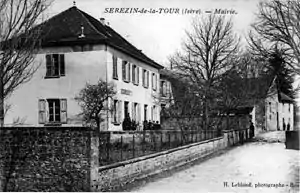 Rathaus von Sérézin-de-la-Tour (Foto von 1908) | ||

Geografie
Sérézin-de-la-Tour liegt etwa 45 Kilometer ostsüdöstlich von Lyon. Umgeben wird Sérézin-de-la-Tour von den Nachbargemeinden Ruy im Norden, Cessieu im Osten und Nordosten, Saint-Victor-de-Cessieu im Osten und Südwesten, Succieu im Süden, Les Éparres im Südwesten sowie Nivolas-Vermelle im Westen. Sérézin liegt an der Bahnstrecke Paris–Marseille.
Bevölkerungsentwicklung
| Jahr | 1962 | 1968 | 1975 | 1982 | 1990 | 1999 | 2006 | 2012 |
| Einwohner | 391 | 386 | 389 | 482 | 529 | 611 | 776 | 925 |
| Quellen: Cassini und INSEE | ||||||||
Sehenswürdigkeiten
- Schloss Quinsonnas
- Wehrhaus von Sérézin
This article is issued from Wikipedia. The text is licensed under Creative Commons - Attribution - Sharealike. The authors of the article are listed here. Additional terms may apply for the media files, click on images to show image meta data.