Nannay
Nannay ist eine französische Gemeinde mit 114 Einwohnern (Stand: 1. Januar 2019) im Département Nièvre in der Region Bourgogne-Franche-Comté. Sie gehört zum Arrondissement Cosne-Cours-sur-Loire und zum Kanton La Charité-sur-Loire.
| Nannay | ||
|---|---|---|
| ||
| Staat | Frankreich | |
| Region | Bourgogne-Franche-Comté | |
| Département (Nr.) | Nièvre (58) | |
| Arrondissement | Cosne-Cours-sur-Loire | |
| Kanton | La Charité-sur-Loire | |
| Gemeindeverband | Communauté de communes Loire, Nièvre et Bertranges | |
| Koordinaten | 47° 16′ N, 3° 12′ O | |
| Höhe | 185–353 m | |
| Fläche | 11,49 km² | |
| Einwohner | 114 (1. Januar 2019) | |
| Bevölkerungsdichte | 10 Einw./km² | |
| Postleitzahl | 58350 | |
| INSEE-Code | 58188 | |
| Website | http://www.nannay.com/ | |
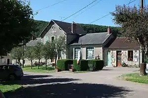 Rathaus (Mairie) von Nannay | ||

Nachbargemeinden
Nannay liegt etwa 30 Kilometer nordnordöstlich von Nevers. An der südwestlichen Gemeindegrenze verläuft der Fluss Mazou. Nachbargemeinden von Nannay sind Châteauneuf-Val-de-Bargis im Norden und Osten, Arbourse im Südosten, Chasnay im Süden, Narcy im Südwesten sowie Vielmanay im Westen und Nordwesten.
Durch die Gemeinde führt die Route nationale 151.
Bevölkerungsentwicklung
| Jahr | 1962 | 1968 | 1975 | 1982 | 1990 | 1999 | 2006 | 2011 | 2016 |
| Einwohner | 178 | 147 | 137 | 135 | 108 | 100 | 125 | 99 | 118 |
| Quellen: Cassini und INSEE | |||||||||
Sehenswürdigkeiten
- Kirche Saint-Aignan aus dem 19. Jahrhundert
- Mühle von Janlard aus dem 16. Jahrhundert
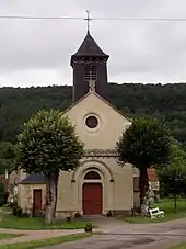
Kirche Saint-Aignan
Literatur
- Le Patrimoine des Communes de la Nièvre. Band 1, Flohic Editions, Charenton-le-Pont 1999, ISBN 2-84234-054-X, S. 132–135.
This article is issued from Wikipedia. The text is licensed under Creative Commons - Attribution - Sharealike. The authors of the article are listed here. Additional terms may apply for the media files, click on images to show image meta data.