Bitry (Nièvre)
Bitry ist eine französische Gemeinde mit 296 Einwohnern (Stand: 1. Januar 2019) im Département Nièvre in der Region Bourgogne-Franche-Comté. Die Gemeinde gehört zum Arrondissement Cosne-Cours-sur-Loire und zum Kanton Pouilly-sur-Loire (bis 2015: Kanton Saint-Amand-en-Puisaye).
| Bitry | ||
|---|---|---|
| ||
| Staat | Frankreich | |
| Region | Bourgogne-Franche-Comté | |
| Département (Nr.) | Nièvre (58) | |
| Arrondissement | Cosne-Cours-sur-Loire | |
| Kanton | Pouilly-sur-Loire | |
| Gemeindeverband | Puisaye-Forterre | |
| Koordinaten | 47° 29′ N, 3° 5′ O | |
| Höhe | 181–328 m | |
| Fläche | 17,67 km² | |
| Einwohner | 296 (1. Januar 2019) | |
| Bevölkerungsdichte | 17 Einw./km² | |
| Postleitzahl | 58310 | |
| INSEE-Code | 58033 | |
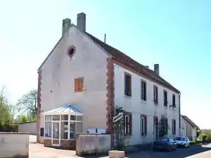 Rathaus (Mairie) von Bitry | ||

Geographie
Bitry liegt etwa 50 Kilometer südwestlich von Auxerre in der Naturlandschaft Puisaye zwischen den Flüssen Loire und Yonne. Umgeben wird Bitry von den Nachbargemeinden Saint-Amand-en-Puisaye im Norden, Dampierre-sous-Bouhy im Osten, Ciez im Südosten, Alligny-Cosne im Süden sowie Saint-Vérain im Westen.
Bevölkerungsentwicklung
| Jahr | 1962 | 1968 | 1975 | 1982 | 1990 | 1999 | 2006 | 2013 | |
| Einwohner | 484 | 425 | 392 | 335 | 305 | 312 | 319 | 320 | |
| Quellen: Cassini und INSEE | |||||||||
Sehenswürdigkeiten
- Kirche Sainte-Foy aus dem 16. Jahrhundert
- Kapelle Saint-Marc
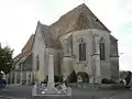 Kirche Sainte-Foy
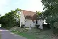 Kapelle Saint-Marc
Literatur
- Le Patrimoine des Communes de la Nièvre. Band 2, Flohic Editions, Charenton-le-Pont 1999, ISBN 2-84234-054-X, S. 877–878.
This article is issued from Wikipedia. The text is licensed under Creative Commons - Attribution - Sharealike. The authors of the article are listed here. Additional terms may apply for the media files, click on images to show image meta data.