Saint-Père (Nièvre)
Saint-Père ist eine französische Gemeinde mit 1.059 Einwohnern (Stand: 1. Januar 2019) im Département Nièvre in der Region Bourgogne-Franche-Comté. Die Gemeinde gehört zum Arrondissement Cosne-Cours-sur-Loire und zum Kanton Cosne-Cours-sur-Loire (bis 2015: Kanton Cosne-Cours-sur-Loire-Sud).
| Saint-Père | ||
|---|---|---|
| ||
| Staat | Frankreich | |
| Region | Bourgogne-Franche-Comté | |
| Département (Nr.) | Nièvre (58) | |
| Arrondissement | Cosne-Cours-sur-Loire | |
| Kanton | Cosne-Cours-sur-Loire | |
| Gemeindeverband | Loire, Vignobles et Nohain | |
| Koordinaten | 47° 25′ N, 2° 58′ O | |
| Höhe | 145–248 m | |
| Fläche | 17,24 km² | |
| Einwohner | 1.059 (1. Januar 2019) | |
| Bevölkerungsdichte | 61 Einw./km² | |
| Postleitzahl | 58200 | |
| INSEE-Code | 58261 | |
| Website | http://www.mairie-saintpere.fr/ | |

Lage
Saint-Père liegt etwa drei Kilometer östlich vom Stadtzentrum von Cosne-Cours-sur-Loire. Umgeben wird Saint-Père von den Nachbargemeinden Cosne-Cours-sur-Loire im Norden, Saint-Loup-des-Bois im Nordosten, Pougny im Osten, Saint-Martin-sur-Nohain im Süden und Cosne-Cours-sur-Loire im Westen.
Bevölkerungsentwicklung
| Jahr | 1962 | 1968 | 1975 | 1982 | 1990 | 1999 | 2006 | 2013 | |
|---|---|---|---|---|---|---|---|---|---|
| Einwohner | 723 | 804 | 871 | 969 | 1.061 | 1.023 | 994 | 1.147 | |
| Quellen: Cassini und INSEE | |||||||||
Sehenswürdigkeiten
- Kirche Saint-Pierre-du-Trépas, seit 1907 Monument historique
- Komtur von Villemoison, seit 1907/1987 Monument historique
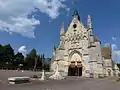 Kirche Saint-Pierre-du-Trépas
 Komtur von Villemoison
Literatur
- Le Patrimoine des Communes de la Nièvre. Band 1, Flohic Editions, Charenton-le-Pont 1999, ISBN 2-84234-054-X, S. 352–353.
This article is issued from Wikipedia. The text is licensed under Creative Commons - Attribution - Sharealike. The authors of the article are listed here. Additional terms may apply for the media files, click on images to show image meta data.