Montsalès
Montsalès (okzitanisch Montsalés) ist eine französische Gemeinde mit 327 Einwohnern (Stand: 1. Januar 2019) im Département Aveyron in der Region Okzitanien (vor 2016 Midi-Pyrénées). Die Gemeinde gehört zum Arrondissement Villefranche-de-Rouergue und zum Kanton Villeneuvois et Villefranchois (bis 2015 Villeneuve). Die Einwohner werden Montsalesiens genannt.
| Montsalès Montsalés | ||
|---|---|---|
| ||
| Staat | Frankreich | |
| Region | Okzitanien | |
| Département (Nr.) | Aveyron (12) | |
| Arrondissement | Villefranche-de-Rouergue | |
| Kanton | Villeneuvois et Villefranchois | |
| Gemeindeverband | Grand Villefranchois | |
| Koordinaten | 44° 30′ N, 1° 58′ O | |
| Höhe | 178–369 m | |
| Fläche | 12,50 km² | |
| Einwohner | 327 (1. Januar 2019) | |
| Bevölkerungsdichte | 26 Einw./km² | |
| Postleitzahl | 12260 | |
| INSEE-Code | 12158 | |
 Kirche Mariä Himmelfahrt | ||

Geografie
Montsalès liegt etwa 55 Kilometer westnordwestlich von Rodez. Umgeben wird Montsalès von den Nachbargemeinden Balaguier-d’Olt im Norden, Foissac im Osten und Nordosten, Villeneuve im Süden und Osten, Ols-et-Rinhodes im Süden sowie Ambeyrac im Westen.
Bevölkerungsentwicklung
| Jahr | 1962 | 1968 | 1975 | 1982 | 1990 | 1999 | 2006 | 2013 |
| Einwohner | 260 | 219 | 195 | 203 | 199 | 215 | 234 | 273 |
| Quelle: Cassini und INSEE | ||||||||
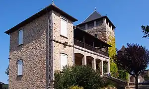
Sehenswürdigkeiten
- Kirche Mariä Himmelfahrt
- Turm und Galerie am Turm
- Höhle von La Gleio de Maôu
Weblinks
Commons: Montsalès – Sammlung von Bildern, Videos und Audiodateien
This article is issued from Wikipedia. The text is licensed under Creative Commons - Attribution - Sharealike. The authors of the article are listed here. Additional terms may apply for the media files, click on images to show image meta data.