Centrès
Centrès (okzitanisch Centres) ist eine französische Gemeinde im Département Aveyron mit 461 Einwohnern (Stand 1. Januar 2019) in der Region Okzitanien (vor 2016 Midi-Pyrénées). Sie ist dem Kanton Ceor-Ségala (bis 2015 Naucelle) und dem Arrondissement Villefranche-de-Rouergue zugeteilt. Die Einwohner werden Centrésiens genannt.
| Centrès | ||
|---|---|---|

|
| |
| Staat | Frankreich | |
| Region | Okzitanien | |
| Département (Nr.) | Aveyron (12) | |
| Arrondissement | Villefranche-de-Rouergue | |
| Kanton | Ceor-Ségala | |
| Gemeindeverband | Pays Ségali | |
| Koordinaten | 44° 10′ N, 2° 25′ O | |
| Höhe | 320–605 m | |
| Fläche | 36,70 km² | |
| Einwohner | 461 (1. Januar 2019) | |
| Bevölkerungsdichte | 13 Einw./km² | |
| Postleitzahl | 12120 | |
| INSEE-Code | 12065 | |
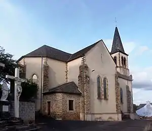 Himmelfahrts-Kirche | ||

Geografie
Centrès liegt etwa 24 Kilometer südsüdwestlich von Rodez im Zentralmassiv. Umgeben wird Centrès von den Nachbargemeinden Camjac im Norden und Westen, Camboulazet im Norden, Sainte-Juliette-sur-Viaur im Nordosten, Cassagnes-Bégonhès im Osten, Rullac-Saint-Cirq im Süden und Südosten, Meljac im Süden sowie Saint-Just-sur-Viaur im Südwesten.
Bevölkerungsentwicklung
| Jahr | 1962 | 1968 | 1975 | 1982 | 1990 | 1999 | 2006 | 2013 |
|---|---|---|---|---|---|---|---|---|
| Einwohner | 1.087 | 1.012 | 933 | 826 | 699 | 599 | 553 | 526 |
| Quelle: Cassini und INSEE | ||||||||
Sehenswürdigkeiten
- Himmelfahrts-Kirche
- Kirche Saint-Étienne im Ortsteil Taurines
- Burg Taurines aus dem 13. Jahrhundert
Weblinks
Commons: Centrès – Sammlung von Bildern, Videos und Audiodateien
This article is issued from Wikipedia. The text is licensed under Creative Commons - Attribution - Sharealike. The authors of the article are listed here. Additional terms may apply for the media files, click on images to show image meta data.