Lanuéjouls
| Lanuéjouls Lanuèjols | ||
|---|---|---|
.svg.png.webp)
|
| |
| Staat | Frankreich | |
| Region | Okzitanien | |
| Département (Nr.) | Aveyron (12) | |
| Arrondissement | Villefranche-de-Rouergue | |
| Kanton | Villeneuvois et Villefranchois | |
| Gemeindeverband | Plateau de Montbazens | |
| Koordinaten | 44° 26′ N, 2° 10′ O | |
| Höhe | 437–556 m | |
| Fläche | 11,84 km² | |
| Einwohner | 723 (1. Januar 2019) | |
| Bevölkerungsdichte | 61 Einw./km² | |
| Postleitzahl | 12350 | |
| INSEE-Code | 12121 | |
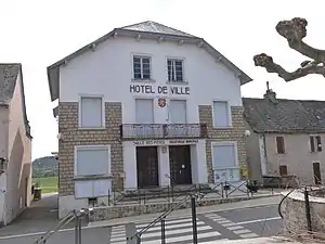 Rathaus (Mairie) von Lanuéjouls | ||

Lanuéjouls (okzitanisch Lanuèjols) ist eine französische Gemeinde mit 723 Einwohnern (Stand: 1. Januar 2019) im Département Aveyron in der Region Okzitanien (vor 2016 Midi-Pyrénées). Die Gemeinde gehört zum Arrondissement Villefranche-de-Rouergue und zum Kanton Villeneuvois et Villefranchois (bis 2015 Montbazens). Die Einwohner werden Lanuéjoulois genannt.
Geografie
Lanuéjouls liegt etwa 31 Kilometer westnordwestlich von Rodez. Umgeben wird Lanuéjouls von den Nachbargemeinden Drulhe im Norden und Nordwesten, Vaureilles im Norden und Nordosten, Privezac im Osten, Compolibat im Süden und Südosten sowie Maleville im Westen und Südwesten.
Einwohnerentwicklung
| Jahr | 1962 | 1968 | 1975 | 1982 | 1990 | 1999 | 2006 | 2013 |
| Einwohner | 779 | 822 | 777 | 744 | 650 | 605 | 701 | 730 |
| Quelle: Cassini und INSEE | ||||||||
Sehenswürdigkeiten
- Kirche Saint-Baudile
- Museum
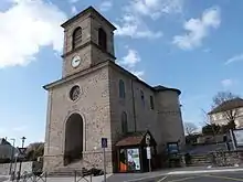
Kirche Saint-Baudile
Weblinks
Commons: Lanuéjouls – Sammlung von Bildern, Videos und Audiodateien
This article is issued from Wikipedia. The text is licensed under Creative Commons - Attribution - Sharealike. The authors of the article are listed here. Additional terms may apply for the media files, click on images to show image meta data.