Montpouillan
Montpouillan (gaskognisch Montpolhan) ist eine französische Gemeinde mit 846 Einwohnern (Stand 1. Januar 2019) im Département Lot-et-Garonne in der Region Nouvelle-Aquitaine (vor 2016 Aquitaine). Die Gemeinde gehört zum Arrondissement Marmande und zum Kanton Marmande-1. Die Einwohner werden Montpouillanais genannt.
| Montpouillan Montpolhan | ||
|---|---|---|
| ||
| Staat | Frankreich | |
| Region | Nouvelle-Aquitaine | |
| Département (Nr.) | Lot-et-Garonne (47) | |
| Arrondissement | Marmande | |
| Kanton | Marmande-1 | |
| Gemeindeverband | Val de Garonne Agglomération | |
| Koordinaten | 44° 28′ N, 0° 6′ O | |
| Höhe | 18–133 m | |
| Fläche | 12,15 km² | |
| Einwohner | 846 (1. Januar 2019) | |
| Bevölkerungsdichte | 70 Einw./km² | |
| Postleitzahl | 47200 | |
| INSEE-Code | 47191 | |
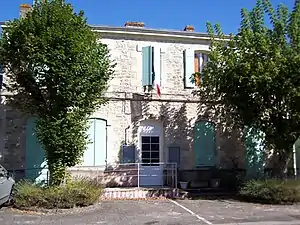 altes Rathaus (Mairie) von Montpouillan | ||

Geografie
Montpouillan liegt etwa sieben Kilometer südwestlich von Marmande am Canal latéral à la Garonne. Umgeben wird Montpouillan von den Nachbargemeinden Marcellus im Norden und Westen, Gaujac im Norden und Nordosten, Marmande im Osten und Nordosten, Fourques-sur-Garonne im Osten, Samazan im Süden und Südosten, Guérin im Südwesten sowie Cocumont im Westen und Südwesten.
Bevölkerungsentwicklung
| 1962 | 1968 | 1975 | 1982 | 1990 | 1999 | 2006 | 2018 | |
|---|---|---|---|---|---|---|---|---|
| 570 | 537 | 521 | 605 | 610 | 557 | 611 | 813 | |
| Quellen: Cassini und INSEE | ||||||||
Kirchen
- Kirche Saint-Jean aus dem 12. Jahrhundert, Monument historique
- Kirche Saint-Étienne von Le Sendex
 Kirche Saint-Jean
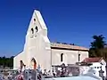 Kirche Saint-Étienne
This article is issued from Wikipedia. The text is licensed under Creative Commons - Attribution - Sharealike. The authors of the article are listed here. Additional terms may apply for the media files, click on images to show image meta data.