Montignargues
Montignargues (okzitanisch: Montinhargues) ist eine französische Gemeinde mit 578 Einwohnern (Stand: 1. Januar 2019) im Département Gard in der Region Okzitanien. Sie gehört zum Arrondissement Nîmes und zum Kanton Calvisson (bis 2015: Kanton Saint-Chaptes).
| Montignargues Montinhargues | ||
|---|---|---|
| ||
| Staat | Frankreich | |
| Region | Okzitanien | |
| Département (Nr.) | Gard (30) | |
| Arrondissement | Nîmes | |
| Kanton | Calvisson | |
| Gemeindeverband | Nîmes Métropole | |
| Koordinaten | 43° 56′ N, 4° 12′ O | |
| Höhe | 79–202 m | |
| Fläche | 4,50 km² | |
| Einwohner | 578 (1. Januar 2019) | |
| Bevölkerungsdichte | 128 Einw./km² | |
| Postleitzahl | 30190 | |
| INSEE-Code | 30180 | |
| Website | https://www.montignargues.fr/ | |
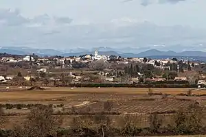 Blick auf Montignargues | ||

Geografie
Montignargues liegt etwa 17 Kilometer nordöstlich des Stadtzentrums von Nîmes und etwa 20 Kilometer südsüdöstlich von Alès. Die Nachbargemeinden von Montignargues sind Saint-Geniès-de-Malgoirès im Norden, La Rouvière im Osten und Südosten, Saint-Bauzély im Süden sowie Montagnac im Westen.
Bevölkerungsentwicklung
| Jahr | 1962 | 1968 | 1975 | 1982 | 1990 | 1999 | 2006 | 2017 |
|---|---|---|---|---|---|---|---|---|
| Einwohner | 94 | 91 | 98 | 180 | 205 | 348 | 554 | 597 |
| Quellen: Cassini und INSEE | ||||||||
Weblinks
Commons: Montignargues – Sammlung von Bildern, Videos und Audiodateien
This article is issued from Wikipedia. The text is licensed under Creative Commons - Attribution - Sharealike. The authors of the article are listed here. Additional terms may apply for the media files, click on images to show image meta data.