Monthureux-le-Sec
Monthureux-le-Sec ist eine auf 420 Metern über Meereshöhe gelegene Gemeinde im französischen Département Vosges in der Region Grand Est (bis 2015 Lothringen). Sie gehört zum Kanton Vittel im Arrondissement Neufchâteau. Sie grenzt im Norden an Haréville und Remoncourt, im Osten an Esley, im Südosten an Senonges, im Südwesten an Thuillières und im Nordwesten an Valleroy-le-Sec. Die Bewohner nennen sich Monthécursiens.
| Monthureux-le-Sec | ||
|---|---|---|
| ||
| Staat | Frankreich | |
| Region | Grand Est | |
| Département (Nr.) | Vosges (88) | |
| Arrondissement | Neufchâteau | |
| Kanton | Vittel | |
| Gemeindeverband | Terre d’Eau | |
| Koordinaten | 48° 10′ N, 6° 2′ O | |
| Höhe | 345–448 m | |
| Fläche | 11,42 km² | |
| Einwohner | 159 (1. Januar 2019) | |
| Bevölkerungsdichte | 14 Einw./km² | |
| Postleitzahl | 88800 | |
| INSEE-Code | 88309 | |
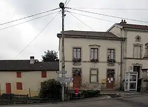 Mairie und Schule in Monthureux-le-Sec | ||

Bevölkerungsentwicklung
| Jahr | 1962 | 1968 | 1975 | 1982 | 1990 | 1999 | 2008 | 2017 |
|---|---|---|---|---|---|---|---|---|
| Einwohner | 207 | 183 | 170 | 196 | 177 | 168 | 160 | 159 |
Sehenswürdigkeiten
- Kirche Saint-Martin
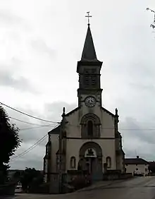
Kirche Saint-Martin
This article is issued from Wikipedia. The text is licensed under Creative Commons - Attribution - Sharealike. The authors of the article are listed here. Additional terms may apply for the media files, click on images to show image meta data.