Aulnois
| Aulnois | ||
|---|---|---|

|
| |
| Staat | Frankreich | |
| Region | Grand Est | |
| Département (Nr.) | Vosges (88) | |
| Arrondissement | Neufchâteau | |
| Kanton | Vittel | |
| Gemeindeverband | Terre d’Eau | |
| Koordinaten | 48° 15′ N, 5° 47′ O | |
| Höhe | 328–430 m | |
| Fläche | 4,42 km² | |
| Einwohner | 166 (1. Januar 2019) | |
| Bevölkerungsdichte | 38 Einw./km² | |
| Postleitzahl | 88300 | |
| INSEE-Code | 88017 | |
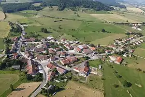
 Blick auf Aulnois | ||
Aulnois ist eine französische Gemeinde mit 166 Einwohnern (Stand: 1. Januar 2019) im Département Vosges in der Region Grand Est (bis 2015 Lothringen). Aulnois gehört zum Arrondissement Neufchâteau und zum Kanton Vittel.
Geografie
Aulnois liegt zwischen Neufchâteau und Vittel am Bach Ruisseau le Bani, einem Zufluss des Mouzon, und wird von der ehemaligen Route nationale 64 (heute: D 164) tangiert. Nachbargemeinden sind Ollainville im Nordosten, Hagnéville-et-Roncourt im Südosten, Beaufremont im Westen sowie Landaville im Nordwesten.
Bevölkerungsentwicklung
| Jahr | 1962 | 1968 | 1985 | 1982 | 1990 | 1999 | 2008 | 2018 |
| Einwohner | 141 | 146 | 149 | 134 | 141 | 123 | 148 | 164 |
Sehenswürdigkeiten
 Mairie Aulnois
 Kirche Paulus' Umwandlung (Église de la Conversion-de-Saint-Paul)
This article is issued from Wikipedia. The text is licensed under Creative Commons - Attribution - Sharealike. The authors of the article are listed here. Additional terms may apply for the media files, click on images to show image meta data.
