Metz-en-Couture
| Metz-en-Couture | ||
|---|---|---|
|
| |
| Staat | Frankreich | |
| Region | Hauts-de-France | |
| Département (Nr.) | Pas-de-Calais (62) | |
| Arrondissement | Arras | |
| Kanton | Bapaume | |
| Gemeindeverband | Sud-Artois | |
| Koordinaten | 50° 4′ N, 3° 4′ O | |
| Höhe | 90–134 m | |
| Fläche | 10,61 km² | |
| Einwohner | 624 (1. Januar 2019) | |
| Bevölkerungsdichte | 59 Einw./km² | |
| Postleitzahl | 62124 | |
| INSEE-Code | 62572 | |
| Website | https://www.metz-en-couture.fr/ | |
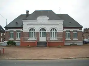 Rathaus (Mairie) von Metz-en-Couture | ||

Metz-en-Couture ist eine französische Gemeinde mit 624 Einwohnern (Stand: 1. Januar 2019) im Département Pas-de-Calais in der Region Hauts-de-France. Sie gehört zum Arrondissement Arras und zum Kanton Bapaume (bis 2015: Kanton Bertincourt). Die Einwohner werden Herminois genannt.
Geographie
Metz-en-Couture liegt etwa 17 Kilometer südsüdwestlich von Cambrai. Umgeben wird Metz-en-Couture von den Nachbargemeinden Havrincourt im Norden, Villers-Plouich im Nordosten, Gouzeaucourt im Osten, Heudicourt im Südosten, Sorel und Fins im Süden sowie Neuville-Bourjonval im Westen.
Bevölkerungsentwicklung
| Jahr | 1962 | 1968 | 1975 | 1982 | 1990 | 1999 | 2006 | 2013 |
| Einwohner | 794 | 714 | 647 | 575 | 605 | 602 | 626 | 663 |
| Quelle: Cassini und INSEE | ||||||||
Sehenswürdigkeiten
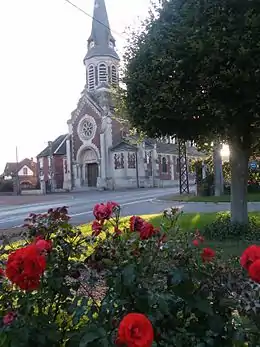
Kirche Metz-en-Couture
- Kirche Saint-Nicolas
- Britischer Militärfriedhof
This article is issued from Wikipedia. The text is licensed under Creative Commons - Attribution - Sharealike. The authors of the article are listed here. Additional terms may apply for the media files, click on images to show image meta data.