Villers-Brûlin
Villers-Brûlin ist eine französische Gemeinde mit 366 Einwohnern (Stand 1. Januar 2019) im Département Pas-de-Calais in der Region Hauts-de-France. Sie gehört zum Arrondissement Arras und zum Kanton Avesnes-le-Comte (bis 2015: Kanton Aubigny-en-Artois).
| Villers-Brûlin | ||
|---|---|---|
.svg.png.webp)
|
| |
| Staat | Frankreich | |
| Region | Hauts-de-France | |
| Département (Nr.) | Pas-de-Calais (62) | |
| Arrondissement | Arras | |
| Kanton | Avesnes-le-Comte | |
| Gemeindeverband | Campagnes de l’Artois | |
| Koordinaten | 50° 22′ N, 2° 32′ O | |
| Höhe | 110–153 m | |
| Fläche | 3,85 km² | |
| Einwohner | 366 (1. Januar 2019) | |
| Bevölkerungsdichte | 95 Einw./km² | |
| Postleitzahl | 62690 | |
| INSEE-Code | 62856 | |
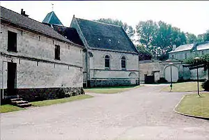 Zentrum von Villers-Brûlin | ||

Geographie
Villers-Brûlin liegt im Norden Frankreichs. Nördlich der Gemeinde liegt Frévillers, nordöstlich Béthonsart, südöstlich Savy-Berlette, südlich Berles-Monchel, südwestlich Tincques und nordwestlich Chelers.
Bevölkerungsentwicklung
| Jahr | 1962 | 1968 | 1975 | 1982 | 1990 | 1999 | 2008 | 2013 |
|---|---|---|---|---|---|---|---|---|
| Einwohner | 280 | 289 | 270 | 278 | 315 | 300 | 313 | 298 |
This article is issued from Wikipedia. The text is licensed under Creative Commons - Attribution - Sharealike. The authors of the article are listed here. Additional terms may apply for the media files, click on images to show image meta data.