Labatmale
Labatmale (okzitanisch: La Vatmala) ist eine französische Gemeinde mit 255 Einwohnern (Stand: 1. Januar 2019) im Département Pyrénées-Atlantiques in der Region Nouvelle-Aquitaine (vor 2016: Aquitanien). Sie gehört zum Arrondissement Pau und ist Teil des Kantons Vallées de l’Ousse et du Lagoin (bis 2015: Kanton Pontacq).
| Labatmale La Vatmala | ||
|---|---|---|
| ||
| Staat | Frankreich | |
| Region | Nouvelle-Aquitaine | |
| Département (Nr.) | Pyrénées-Atlantiques (64) | |
| Arrondissement | Pau | |
| Kanton | Vallées de l’Ousse et du Lagoin | |
| Gemeindeverband | Pays de Nay | |
| Koordinaten | 43° 11′ N, 0° 9′ W | |
| Höhe | 350–480 m | |
| Fläche | 3,32 km² | |
| Einwohner | 255 (1. Januar 2019) | |
| Bevölkerungsdichte | 77 Einw./km² | |
| Postleitzahl | 64530 | |
| INSEE-Code | 64292 | |

Geografie
Labatmale liegt etwa 21 Kilometer südöstlich von Pau am Fuß der Pyrenäen. Umgeben wird Labatmale von den Nachbargemeinden Bénéjacq im Norden und Westen, Pontacq im Osten sowie Saint-Vincent im Süden.
Bevölkerungsentwicklung
| 1962 | 1968 | 1975 | 1982 | 1990 | 1999 | 2006 | 2013 | |
|---|---|---|---|---|---|---|---|---|
| 195 | 188 | 199 | 208 | 212 | 203 | 244 | 249 | |
| Quelle: Cassini und INSEE | ||||||||
Sehenswürdigkeiten
- Kirche Saint-Sébastien, Anfang des 18. Jahrhunderts erbaut
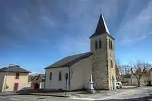
Kirche Saint-Sébastien
This article is issued from Wikipedia. The text is licensed under Creative Commons - Attribution - Sharealike. The authors of the article are listed here. Additional terms may apply for the media files, click on images to show image meta data.