Kanton Sarlat-la-Canéda
Der Kanton Sarlat-la-Canéda ist ein französischer Kanton im Arrondissement Sarlat-la-Canéda im Département Dordogne in der Region Nouvelle-Aquitaine; sein Hauptort ist Sarlat-la-Canéda, Vertreter im Generalrat des Départements ist seit 2004 Jean-Fred Droin.
| Kanton Sarlat-la-Canéda | |
|---|---|
| Region | Nouvelle-Aquitaine |
| Département | Dordogne |
| Arrondissement | Sarlat-la-Canéda |
| Hauptort | Sarlat-la-Canéda |
| Einwohner | 16.085 (1. Jan. 2019) |
| Bevölkerungsdichte | 69 Einw./km² |
| Fläche | 234,43 km² |
| Gemeinden | 13 |
| INSEE-Code | 2418 |
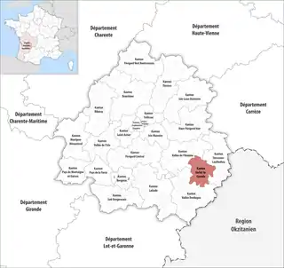 Lage des Kantons Sarlat-la-Canéda im Département Dordogne | |
Gemeinden
Der Kanton besteht aus 13 Gemeinden mit insgesamt 16.085 Einwohnern (Stand: 1. Januar 2019) auf einer Gesamtfläche von 234,43 km²:
| Gemeinde | Einwohner 1. Januar 2019 |
Fläche km² |
Dichte Einw./km² |
Code INSEE |
Postleitzahl |
|---|---|---|---|---|---|
| Beynac-et-Cazenac | 544 | 13,10 | 42 | 24040 | 24220 |
| La Roque-Gageac | 427 | 7,21 | 59 | 24355 | 24250 |
| Marcillac-Saint-Quentin | 815 | 17,06 | 48 | 24252 | 24200 |
| Marquay | 584 | 25,02 | 23 | 24255 | 24620 |
| Proissans | 1.043 | 18,19 | 57 | 24341 | 24200 |
| Saint-André-d’Allas | 856 | 29,47 | 29 | 24366 | 24200 |
| Sainte-Nathalène | 625 | 13,92 | 45 | 24471 | 24200 |
| Saint-Vincent-de-Cosse | 361 | 7,29 | 50 | 24510 | 24220 |
| Saint-Vincent-le-Paluel | 287 | 7,07 | 41 | 24512 | 24200 |
| Sarlat-la-Canéda | 8.816 | 48,60 | 181 | 24520 | 24200 |
| Tamniès | 386 | 19,51 | 20 | 24544 | 24620 |
| Vézac | 524 | 13,57 | 39 | 24577 | 24220 |
| Vitrac | 817 | 14,42 | 57 | 24587 | 24200 |
| Kanton Sarlat-la-Canéda | 16.085 | 234,43 | 69 | 2418 | – |
Bis zur landesweiten Neuordnung der französischen Kantone im März 2015 gehörten zum Kanton Sarlat-la-Canéda bis auf die Gemeinde Saint-Vincent-de-Cosse die gleichen Gemeinden. Sein Zuschnitt entsprach einer Fläche von 220,97 km2. Er besaß vor 2015 einen anderen INSEE-Code als heute, nämlich 2436.
Bevölkerungsentwicklung
| 1962 | 1968 | 1975 | 1982 | 1990 | 1999 |
|---|---|---|---|---|---|
| 11.662 | 12.937 | 13.950 | 14.371 | 15.337 | 15.512 |
This article is issued from Wikipedia. The text is licensed under Creative Commons - Attribution - Sharealike. The authors of the article are listed here. Additional terms may apply for the media files, click on images to show image meta data.