Heinersreuther Forst
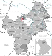
Der Heinersreuther Forst ist ein 7,61 km²[1] großes gemeindefreies Gebiet im Landkreis Bayreuth westlich von Bayreuth.
Schutzgebiete
_1.1.16_(6).JPG.webp)
Geotope
- Teufelslochgraben nördlich von Oberwaiz (Geotop-Nummer 472R019).
- Ehemaliger Steinbruch Kühloch ostsüdöstlich von Neustädtlein (Geotop-Nummer 472A008)
Einzelnachweise
- Flächenangaben bei www.destatis.de, Stand 31. Dezember 2018, abgerufen am 1. August 2020.
Weblinks
- Heinersreuther Forst in OpenStreetMap (Abgerufen am 1. November 2015)

Ahorntal | Aufseß | Bad Berneck im Fichtelgebirge | Betzenstein | Bindlach | Bischofsgrün | Creußen | Eckersdorf | Emtmannsberg | Fichtelberg | Gefrees | Gesees | Glashütten | Goldkronach | Haag | Heinersreuth | Hollfeld | Hummeltal | Kirchenpingarten | Mehlmeisel | Mistelbach | Mistelgau | Pegnitz | Plankenfels | Plech | Pottenstein | Prebitz | Schnabelwaid | Seybothenreuth | Speichersdorf | Waischenfeld | Warmensteinach | Weidenberg
Gemeindefreie Gebiete
Bischofsgrüner Forst |
Fichtelberg |
Forst Neustädtlein am Forst |
Glashüttener Forst |
Heinersreuther Forst |
Neubauer Forst-Nord |
Prüll |
Veldensteiner Forst |
Waidacher Forst |
Warmensteinacher Forst-Nord