Corquilleroy
Corquilleroy ist eine französische Gemeinde mit 2.815 Einwohnern (Stand: 1. Januar 2019) im Département Loiret in der Region Centre-Val de Loire. Sie ist Teil des Kantons Châlette-sur-Loing im Arrondissement Montargis. Die Einwohner werden Guillerois genannt.
| Corquilleroy | ||
|---|---|---|
| ||
| Staat | Frankreich | |
| Region | Centre-Val de Loire | |
| Département (Nr.) | Loiret (45) | |
| Arrondissement | Montargis | |
| Kanton | Châlette-sur-Loing | |
| Gemeindeverband | Montargoise et Rives du Loing | |
| Koordinaten | 48° 3′ N, 2° 42′ O | |
| Höhe | 80–102 m | |
| Fläche | 13,94 km² | |
| Einwohner | 2.815 (1. Januar 2019) | |
| Bevölkerungsdichte | 202 Einw./km² | |
| Postleitzahl | 45700 | |
| INSEE-Code | 45104 | |
| Website | http://www.corquilleroy.fr/ | |
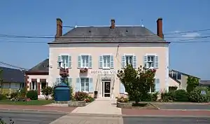 Rathaus (Hôtel de ville) | ||

Geografie
Der Canal d’Orléans begrenzt die Gemeinde im Osten. Umgeben wird Corquilleroy von Treilles-en-Gâtinais im Norden und Nordwesten, Girolles im Norden und Nordosten, Cepoy im Nordosten, Châlette-sur-Loing im Osten und Südosten, Pannes im Süden und Südwesten sowie Gondreville im Nordwesten.
Durch die Gemeinde führen die Autoroute A19 und die Autoroute A77.
Bevölkerungsentwicklung
| 1962 | 1968 | 1975 | 1982 | 1990 | 1999 | 2006 | 2011 | 2018 |
|---|---|---|---|---|---|---|---|---|
| 1503 | 1650 | 1788 | 1842 | 1893 | 2108 | 2395 | 2682 | 2798 |
Sehenswürdigkeiten
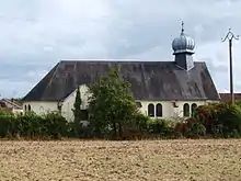
Kirche Sainte-Olga
- Ukrainisch-Orthodoxe Kirche Sainte-Olga
- Kirche Saint-Martin von 1863

Kirche Saint-Martin
Weblinks
Commons: Corquilleroy – Sammlung von Bildern, Videos und Audiodateien
This article is issued from Wikipedia. The text is licensed under Creative Commons - Attribution - Sharealike. The authors of the article are listed here. Additional terms may apply for the media files, click on images to show image meta data.