La Chapelle-sur-Aveyron
La Chapelle-sur-Aveyron ist eine französische Gemeinde mit 626 Einwohnern (Stand: 1. Januar 2019) im Département Loiret in der Region Centre-Val de Loire. Sie ist Teil des Kantons Lorris im Arrondissement Montargis. Die Einwohner werden Chapellois genannt.
| La Chapelle-sur-Aveyron | ||
|---|---|---|
.svg.png.webp)
|
| |
| Staat | Frankreich | |
| Region | Centre-Val de Loire | |
| Département (Nr.) | Loiret (45) | |
| Arrondissement | Montargis | |
| Kanton | Lorris | |
| Gemeindeverband | Canaux et Forêts en Gâtinais | |
| Koordinaten | 47° 52′ N, 2° 52′ O | |
| Höhe | 114–182 m | |
| Fläche | 19,00 km² | |
| Einwohner | 626 (1. Januar 2019) | |
| Bevölkerungsdichte | 33 Einw./km² | |
| Postleitzahl | 45230 | |
| INSEE-Code | 45077 | |

Geographie
La Chapelle-sur-Aveyron liegt etwa 70 Kilometer ostsüdöstlich von Orléans und am Aveyron. Umgeben wird La Chapelle-sur-Aveyron von den Nachbargemeinden Château-Renard im Norden und Nordosten, Melleroy im Nordosten, Saint-Maurice-sur-Aveyron im Osten und Südosten, Châtillon-Coligny im Süden sowie Montbouy im Westen.
Bevölkerungsentwicklung
| 1962 | 1968 | 1975 | 1982 | 1990 | 1999 | 2006 | 2018 | |
|---|---|---|---|---|---|---|---|---|
| 423 | 377 | 329 | 323 | 361 | 392 | 471 | 630 | |
| Quellen: Cassini und INSEE | ||||||||
Sehenswürdigkeiten
- Kirche Saint-Loup-et-Saint-Roch aus dem 11. Jahrhundert
- Schloss Les Ballus, 1820 erbaut
- Mühle von La Gravière
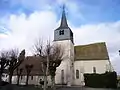 Kirche Saint-Loup-et-Saint-Roch
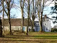 Schloss Les Ballus
Weblinks
Commons: La Chapelle-sur-Aveyron – Sammlung von Bildern, Videos und Audiodateien
This article is issued from Wikipedia. The text is licensed under Creative Commons - Attribution - Sharealike. The authors of the article are listed here. Additional terms may apply for the media files, click on images to show image meta data.