Louzouer
Louzouer ist eine französische Gemeinde mit 250 Einwohnern (Stand: 1. Januar 2019) im Département Loiret in der Region Centre-Val de Loire. Sie gehört zum Arrondissement Montargis und ist Teil des Kantons Courtenay. Die Einwohner werden Oratoriens genannt.
| Louzouer | ||
|---|---|---|
| ||
| Staat | Frankreich | |
| Region | Centre-Val de Loire | |
| Département (Nr.) | Loiret (45) | |
| Arrondissement | Montargis | |
| Kanton | Courtenay | |
| Gemeindeverband | Cléry, Betz et l’Ouanne | |
| Koordinaten | 48° 2′ N, 2° 53′ O | |
| Höhe | 112–138 m | |
| Fläche | 11,19 km² | |
| Einwohner | 250 (1. Januar 2019) | |
| Bevölkerungsdichte | 22 Einw./km² | |
| Postleitzahl | 45210 | |
| INSEE-Code | 45189 | |
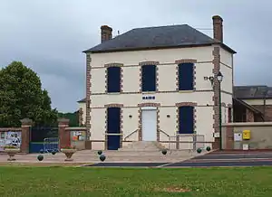 Rathaus (Mairie) von Louzouer | ||

Geografie
Louzouer liegt etwa 71 Kilometer ostnordöstlich von Orléans. Nachbargemeinden von Louzouer sind Griselles im Norden und Nordwesten, La Selle-sur-le-Bied im Norden, Saint-Loup-de-Gonois im Nordosten, Courtemaux im Osten und Nordosten, Thorailles im Osten und Südosten, La Selle-en-Hermoy im Süden, La Chapelle-Saint-Sépulcre im Westen und Südwesten sowie Paucourt im Westen.
Bevölkerungsentwicklung
| Jahr | 1962 | 1968 | 1975 | 1982 | 1990 | 1999 | 2006 | 2018 |
| Einwohner | 151 | 154 | 147 | 182 | 226 | 277 | 271 | 254 |
| Quellen: Cassini und INSEE | ||||||||
Sehenswürdigkeiten
- Menhir Pierre de Minuit
- Kirche Saint-Martin
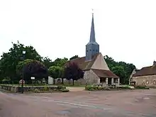
Kirche Saint-Martin
_-_vue_arri%C3%A8re.jpg.webp)
Menhir Pierre de Minuit
Weblinks
Commons: Louzouer – Sammlung von Bildern, Videos und Audiodateien
This article is issued from Wikipedia. The text is licensed under Creative Commons - Attribution - Sharealike. The authors of the article are listed here. Additional terms may apply for the media files, click on images to show image meta data.