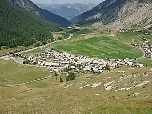
Ceillac
Ceillac ist eine südfranzösische Gemeinde im Département Hautes-Alpes in der Region Provence-Alpes-Côte d’Azur. Sie gehört zum Arrondissement Briançon und zum Kanton Guillestre. Die Bewohner nennen sich Ceillaquins.
| Ceillac | ||
|---|---|---|

|
| |
| Staat | Frankreich | |
| Region | Provence-Alpes-Côte d’Azur | |
| Département (Nr.) | Hautes-Alpes (05) | |
| Arrondissement | Briançon | |
| Kanton | Guillestre | |
| Gemeindeverband | Guillestrois et Queyras | |
| Koordinaten | 44° 40′ N, 6° 47′ O | |
| Höhe | 1224–3381 m | |
| Fläche | 96,06 km² | |
| Einwohner | 285 (1. Januar 2019) | |
| Bevölkerungsdichte | 3 Einw./km² | |
| Postleitzahl | 05600 | |
| INSEE-Code | 05026 | |
 Ceillac | ||

Geographie
Die Gemeinde liegt rund 30 Kilometer (Luftlinie) südsüdöstlich von Briançon im Tal des Flusses Cristillan. Nachbargemeinden sind Château-Ville-Vieille und Molines-en-Queyras im Norden, Saint-Véran im Nordosten, Saint-Paul-sur-Ubaye im Südosten, Vars im Südwesten und Guillestre im Nordwesten.
Das Gemeindegebiet gehört zum Regionalen Naturpark Queyras.
Bevölkerungsentwicklung
| Jahr | 1962 | 1968 | 1975 | 1982 | 1990 | 1999 | 2008 | 2014 |
|---|---|---|---|---|---|---|---|---|
| Einwohner | 202 | 208 | 234 | 292 | 289 | 276 | 304 | 296 |
Sehenswürdigkeiten
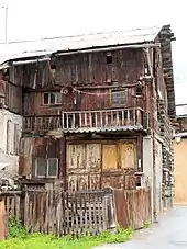
Maison Chabrand
- Maison Chabrand, Monument historique
- Kirche Saint-Sébastian, Monument historique
- Kirche Sainte-Cécile, Monument historique
This article is issued from Wikipedia. The text is licensed under Creative Commons - Attribution - Sharealike. The authors of the article are listed here. Additional terms may apply for the media files, click on images to show image meta data.