Val-des-Prés
Val-des-Prés ist eine französische Gemeinde im Département Hautes-Alpes in der Region Provence-Alpes-Côte d’Azur. Sie gehört zum Kanton Briançon-2 im Arrondissement Briançon.
| Val-des-Prés | ||
|---|---|---|

|
| |
| Staat | Frankreich | |
| Region | Provence-Alpes-Côte d’Azur | |
| Département (Nr.) | Hautes-Alpes (05) | |
| Arrondissement | Briançon | |
| Kanton | Briançon-2 | |
| Gemeindeverband | Briançonnais | |
| Koordinaten | 44° 57′ N, 6° 41′ O | |
| Höhe | 1338–2761 m | |
| Fläche | 44,71 km² | |
| Einwohner | 615 (1. Januar 2019) | |
| Bevölkerungsdichte | 14 Einw./km² | |
| Postleitzahl | 05100 | |
| INSEE-Code | 05174 | |
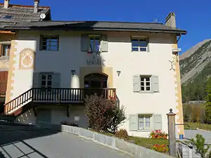 Mairie Val-des-Prés | ||

Geografie
Der Clarée fließt von Norden nach Süden und passiert die Hauptsiedlung sowie die Weiler La Draye und Le Rosier. Val-des-Prés grenzt im Norden an Névache, im Osten an Montgenèvre, im Süden an Cervières und Briançon sowie im Westen an Saint-Chaffrey und La Salle-les-Alpes.
Bevölkerungsentwicklung
| Jahr | 1962 | 1968 | 1975 | 1982 | 1990 | 1999 | 2008 | 2012 |
|---|---|---|---|---|---|---|---|---|
| Einwohner | 239 | 217 | 276 | 390 | 479 | 450 | 502 | 579 |
Sehenswürdigkeiten
- Haus mit Sonnenuhr von Zarbura, Monument historique
- Kirche Église de l’Annonciation de Val-des-Prés, ein Monument historique
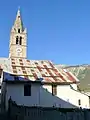
- Kirche Saint-Claude
 Église de l’Annonciation
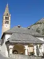 Kirche Saint-Claude
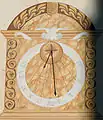 Sonnenuhr an der Mairie
This article is issued from Wikipedia. The text is licensed under Creative Commons - Attribution - Sharealike. The authors of the article are listed here. Additional terms may apply for the media files, click on images to show image meta data.