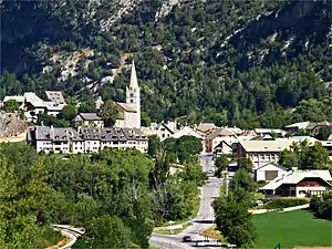
Saint-Crépin (Hautes-Alpes)
Saint-Crépin ist eine französische Gemeinde im Département Hautes-Alpes in der Region Provence-Alpes-Côte d’Azur. Sie gehört zum Kanton Guillestre im Arrondissement Briançon.
| Saint-Crépin | ||
|---|---|---|
.svg.png.webp)
|
| |
| Staat | Frankreich | |
| Region | Provence-Alpes-Côte d’Azur | |
| Département (Nr.) | Hautes-Alpes (05) | |
| Arrondissement | Briançon | |
| Kanton | Guillestre | |
| Gemeindeverband | Guillestrois et Queyras | |
| Koordinaten | 44° 42′ N, 6° 36′ O | |
| Höhe | 894–2905 m | |
| Fläche | 46,98 km² | |
| Einwohner | 737 (1. Januar 2019) | |
| Bevölkerungsdichte | 16 Einw./km² | |
| Postleitzahl | 05600 | |
| INSEE-Code | 05136 | |
 Saint-Crépin | ||

Geographie
Durch Saint-Crépin fließt die Durance. Saint-Crépin grenzt im Nordosten an Arvieux, im Südosten an Eygliers, im Südwesten an Réotier und Champcella sowie im Nordwesten an La Roche-de-Rame.
Bevölkerungsentwicklung
| Jahr | 1962 | 1968 | 1975 | 1982 | 1990 | 1999 | 2006 | 2018 |
|---|---|---|---|---|---|---|---|---|
| Einwohner | 409 | 400 | 402 | 507 | 533 | 541 | 583 | 735 |
Sehenswürdigkeiten
- Kirche Saint-Crépin-et-Saint-Crépinien, Monument historique
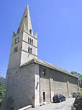
Kirche Saint-Crépin-et-Saint-Crépinien
This article is issued from Wikipedia. The text is licensed under Creative Commons - Attribution - Sharealike. The authors of the article are listed here. Additional terms may apply for the media files, click on images to show image meta data.