Villar-Saint-Pancrace
Villar-Saint-Pancrade (auch Grand Villar oder Le Villar genannt) ist eine französische Gemeinde im Département Hautes-Alpes in der Region Provence-Alpes-Côte d’Azur. Sie gehört zum Kanton Briançon-1 im Arrondissement Briançon. Die Bewohner nennen sich Viarans oder Vialans.
| Villar-Saint-Pancrace | ||
|---|---|---|
| ||
| Staat | Frankreich | |
| Region | Provence-Alpes-Côte d’Azur | |
| Département (Nr.) | Hautes-Alpes (05) | |
| Arrondissement | Briançon | |
| Kanton | Briançon-1 | |
| Gemeindeverband | Briançonnais | |
| Koordinaten | 44° 52′ N, 6° 38′ O | |
| Höhe | 1160–2903 m | |
| Fläche | 42,75 km² | |
| Einwohner | 1.477 (1. Januar 2019) | |
| Bevölkerungsdichte | 35 Einw./km² | |
| Postleitzahl | 05100 | |
| INSEE-Code | 05183 | |
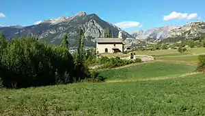 Kapelle Saint-Pancrace | ||

Geografie
Villar-Saint-Pancrade befindet sich im Bereich der französischen Seealpen und grenzt im Norden an Briançon, im Osten an Cervières, im Südosten an Arvieux, im Süden an La Roche-de-Rame, im Westen an Saint-Martin-de-Queyrières und im Nordwesten an Puy-Saint-André.
Örtliche Erhebungen heißen:
- Le Mélézin (1879 m)
- Le Lauzin (1500 m)
- Le Clot des Prés (1570 m)
- Les Prés du Vallon (1720 m)
- Pied-Sec (1960 m)
- Les Ayes (1715 m)
- Vers-le-Col
- L’Orceyrette
- L’Orcière
- L’Alp resp. L’Are (2200 m)
- La Taure (2100 m)
Bevölkerungsentwicklung
| Jahr | 1962 | 1968 | 1975 | 1982 | 1990 | 1999 | 2008 | 2018 |
|---|---|---|---|---|---|---|---|---|
| Einwohner | 899 | 960 | 1023 | 1117 | 1287 | 1410 | 1452 | 1476 |
Sehenswürdigkeiten
- Chapelle des Pénitents, Monument historique
- Kapelle Saint-Pancrace, Monument historique
- Kirche Saint-Pancrace, Monument historique
This article is issued from Wikipedia. The text is licensed under Creative Commons - Attribution - Sharealike. The authors of the article are listed here. Additional terms may apply for the media files, click on images to show image meta data.