Arvieux
Arvieux ist eine französische Gemeinde im Département Hautes-Alpes in der Region Provence-Alpes-Côte d’Azur. Sie gehört zum Arrondissement Briançon und zum Kanton Guillestre (bis 2015 Kanton Aiguilles).
| Arvieux | ||
|---|---|---|

|
| |
| Staat | Frankreich | |
| Region | Provence-Alpes-Côte d’Azur | |
| Département (Nr.) | Hautes-Alpes (05) | |
| Arrondissement | Briançon | |
| Kanton | Guillestre | |
| Gemeindeverband | Guillestrois et Queyras | |
| Koordinaten | 44° 46′ N, 6° 44′ O | |
| Höhe | 1138–2910 m | |
| Fläche | 73,16 km² | |
| Einwohner | 358 (1. Januar 2019) | |
| Bevölkerungsdichte | 5 Einw./km² | |
| Postleitzahl | 05350 | |
| INSEE-Code | 05007 | |
 Arvieux | ||

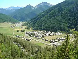
Geographie
Das Gemeindegebiet gehört zum Regionalen Naturpark Queyras. Die angrenzenden Gemeinden sind Cevrières im Norden, Château-Ville-Vieille im Osten, Guillestre im Südosten, Eygliers im Südwesten, Saint-Crépin und La Roche-de-Rame im Westen sowie Villar-Saint-Pancrace im Nordwesten.
Bevölkerungsentwicklung
| Jahr | 1962 | 1968 | 1975 | 1982 | 1990 | 1999 | 2005 | 2006 | 2012 |
|---|---|---|---|---|---|---|---|---|---|
| Einwohner | 413 | 412 | 324 | 351 | 338 | 355 | 347 | 348 | 371 |
Sehenswürdigkeiten
- Kirchen St-Laurent und Ste-Marie-Madeleine, beide als Monument historique klassifiziert
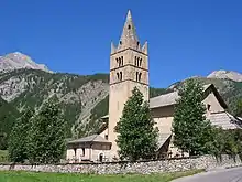 Kirche St-Laurent
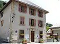 Mairie (Rathaus)
 Lac Roue
This article is issued from Wikipedia. The text is licensed under Creative Commons - Attribution - Sharealike. The authors of the article are listed here. Additional terms may apply for the media files, click on images to show image meta data.