Braisnes-sur-Aronde
Braisnes-sur-Aronde (früher nur: Braisnes) ist eine französische Gemeinde mit 172 Einwohnern (Stand: 1. Januar 2019) im Département Oise in der Region Hauts-de-France (vor 2016 Picardie). Sie gehört zum Arrondissement Compiègne und zum Kanton Estrées-Saint-Denis (bis 2015 Ressons-sur-Matz).
| Braisnes-sur-Aronde | ||
|---|---|---|
| ||
| Staat | Frankreich | |
| Region | Hauts-de-France | |
| Département (Nr.) | Oise (60) | |
| Arrondissement | Compiègne | |
| Kanton | Estrées-Saint-Denis | |
| Gemeindeverband | Pays des Sources | |
| Koordinaten | 49° 29′ N, 2° 47′ O | |
| Höhe | 42–92 m | |
| Fläche | 2,63 km² | |
| Einwohner | 172 (1. Januar 2019) | |
| Bevölkerungsdichte | 65 Einw./km² | |
| Postleitzahl | 60113 | |
| INSEE-Code | 60099 | |
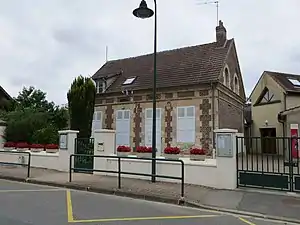 Mairie Braisnes-sur-Aronde | ||

Geographie
Braisnes-sur-Aronde liegt etwa neun Kilometer nordnordwestlich von Compiègne. Umgeben wird Braisnes-sur-Aronde von den Nachbargemeinden Antheuil-Portes im Norden und Nordwesten, Vignemont im Norden und Nordosten, Villers-sur-Coudun im Osten, Coudun im Süden und Südosten, Baugy im Südwesten sowie Monchy-Humières im Westen.
Bevölkerungsentwicklung
| Jahr | 1962 | 1968 | 1975 | 1982 | 1990 | 1999 | 2006 | 2018 |
| Einwohner | 99 | 106 | 101 | 110 | 159 | 179 | 159 | 171 |
| Quellen: Cassini und INSEE | ||||||||
Sehenswürdigkeiten
- Kirche Saint-Étienne (siehe auch: Liste der Monuments historiques in Braisnes-sur-Aronde)
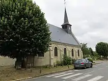
Kirche Saint-Étienne
This article is issued from Wikipedia. The text is licensed under Creative Commons - Attribution - Sharealike. The authors of the article are listed here. Additional terms may apply for the media files, click on images to show image meta data.