Boissy-lès-Perche
Boissy-lès-Perche ist eine französische Gemeinde mit 485 Einwohnern (Stand: 1. Januar 2019) im Département Eure-et-Loir in der Region Centre-Val de Loire; sie gehört zum Arrondissement Dreux und ist Teil des Kantons Saint-Lubin-des-Joncherets (bis 2015: Kanton La Ferté-Vidame).
| Boissy-lès-Perche | ||
|---|---|---|
| ||
| Staat | Frankreich | |
| Region | Centre-Val de Loire | |
| Département (Nr.) | Eure-et-Loir (28) | |
| Arrondissement | Dreux | |
| Kanton | Saint-Lubin-des-Joncherets | |
| Gemeindeverband | Agglo du Pays de Dreux | |
| Koordinaten | 48° 41′ N, 0° 53′ O | |
| Höhe | 165–233 m | |
| Fläche | 33,74 km² | |
| Einwohner | 485 (1. Januar 2019) | |
| Bevölkerungsdichte | 14 Einw./km² | |
| Postleitzahl | 28270 | |
| INSEE-Code | 28046 | |

Geographie
Boissy-lès-Perche liegt etwa 55 Kilometer nordwestlich von Chartres am Fluss Buternay. Umgeben wird Boissy-lès-Perche von den Nachbargemeinden Verneuil d’Avre et d’Iton im Norden, Rueil-la-Gadelière im Osten und Nordosten, Beauche im Osten, Morvilliers im Südosten, Lamblore im Süden, La Chapelle-Fortin im Südwesten, Rohaire im Westen sowie Saint-Victor-sur-Avre im Nordwesten.
Bevölkerungsentwicklung
| Jahr | 1962 | 1968 | 1975 | 1982 | 1990 | 1999 | 2006 | 2017 |
|---|---|---|---|---|---|---|---|---|
| Einwohner | 513 | 474 | 418 | 507 | 513 | 534 | 521 | 498 |
| Quellen: Cassini und INSEE | ||||||||
Sehenswürdigkeiten
- Kirche Saint-Pierre aus dem 15./16. Jahrhundert
- früheres Trappistinnenkloster La Cour Pétral
- Schloss Courangère
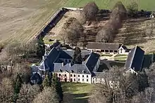
Luftbild von La Cour-Pétral
Weblinks
Commons: Boissy-lès-Perche – Sammlung von Bildern, Videos und Audiodateien
This article is issued from Wikipedia. The text is licensed under Creative Commons - Attribution - Sharealike. The authors of the article are listed here. Additional terms may apply for the media files, click on images to show image meta data.