Lamblore
Lamblore ist eine französische Gemeinde mit 325 Einwohnern (Stand: 1. Januar 2019) im Département Eure-et-Loir in der Region Centre-Val de Loire; sie gehört zum Arrondissement Dreux und ist Teil des Kantons Saint-Lubin-des-Joncherets (bis 2015: Kanton La Ferté-Vidame).
| Lamblore | ||
|---|---|---|
| ||
| Staat | Frankreich | |
| Region | Centre-Val de Loire | |
| Département (Nr.) | Eure-et-Loir (28) | |
| Arrondissement | Dreux | |
| Kanton | Saint-Lubin-des-Joncherets | |
| Gemeindeverband | Agglo du Pays de Dreux | |
| Koordinaten | 48° 38′ N, 0° 55′ O | |
| Höhe | 214–252 m | |
| Fläche | 10,81 km² | |
| Einwohner | 325 (1. Januar 2019) | |
| Bevölkerungsdichte | 30 Einw./km² | |
| Postleitzahl | 28340 | |
| INSEE-Code | 28202 | |

Geographie
Lamblore liegt etwa 525 Kilometer nordwestlich von Chartres. Umgeben wird Lamblore von den Nachbargemeinden Boissy-lès-Perche im Norden, Morvilliers im Norden und Nordosten, La Puisaye im Osten und Südosten, Les Ressuintes im Süden und Südosten sowie La Ferté-Vidame im Süden und Westen.
Bevölkerungsentwicklung
| Jahr | 1962 | 1968 | 1975 | 1982 | 1990 | 1999 | 2006 | 2017 |
|---|---|---|---|---|---|---|---|---|
| Einwohner | 273 | 268 | 214 | 319 | 358 | 375 | 394 | 333 |
| Quelle: Cassini und INSEE | ||||||||
Sehenswürdigkeiten
- Kirche Saint-Martin
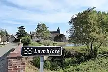
Kirche Saint-Martin (im Hintergrund)
Weblinks
Commons: Lamblore – Sammlung von Bildern, Videos und Audiodateien
This article is issued from Wikipedia. The text is licensed under Creative Commons - Attribution - Sharealike. The authors of the article are listed here. Additional terms may apply for the media files, click on images to show image meta data.