La Framboisière
La Framboisière ist eine französische Gemeinde mit 341 Einwohnern (Stand: 1. Januar 2019) im Département Eure-et-Loir in der Region Centre-Val de Loire. La Framboisière gehört zum Arrondissement Chartres und ist Teil des Kantons Saint-Lubin-des-Joncherets (bis 2015: Kanton Senonches).
| La Framboisière | ||
|---|---|---|
| ||
| Staat | Frankreich | |
| Region | Centre-Val de Loire | |
| Département (Nr.) | Eure-et-Loir (28) | |
| Arrondissement | Dreux | |
| Kanton | Saint-Lubin-des-Joncherets | |
| Gemeindeverband | Forêts du Perche | |
| Koordinaten | 48° 36′ N, 1° 1′ O | |
| Höhe | 194–228 m | |
| Fläche | 5,11 km² | |
| Einwohner | 341 (1. Januar 2019) | |
| Bevölkerungsdichte | 67 Einw./km² | |
| Postleitzahl | 28250 | |
| INSEE-Code | 28159 | |
| Website | http://mairie-la-framboisiere.fr/ | |

Geographie
La Framboisière liegt etwa 26 Kilometer westnordwestlich von Chartres. Umgeben wird La Framboisière von den Nachbargemeinden La Saucelle im Norden, Louvilliers-lès-Perche im Osten, Senonches im Süden sowie La Puisaye im Westen.
Geschichte
Von 1973 bis 1987 waren La Framboisière und La Saucelle zur Gemeinde La Framboisière-la-Saucelle vereinigt.
Bevölkerung
| Bevölkerungsentwicklung | ||||||||
|---|---|---|---|---|---|---|---|---|
| Jahr | 1962 | 1968 | 1975 | 1982 | 1990 | 1999 | 2006 | 2013 |
| Einwohner | 243 | 192 | 316 | 353 | 289 | 297 | 301 | 349 |
| Quelle: Cassini und INSEE | ||||||||
Sehenswürdigkeiten
- Kirche Sainte-Marie-Madeleine
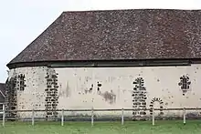
Kirche Sainte-Marie-Madeleine
Weblinks
Commons: La Framboisière – Sammlung von Bildern, Videos und Audiodateien
This article is issued from Wikipedia. The text is licensed under Creative Commons - Attribution - Sharealike. The authors of the article are listed here. Additional terms may apply for the media files, click on images to show image meta data.