Saint-Lubin-de-la-Haye
Saint-Lubin-de-la-Haye ist eine französische Gemeinde mit 933 Einwohnern (Stand: 1. Januar 2019) im Département Eure-et-Loir in der Région Centre-Val de Loire in Frankreich. Sie gehört zum Kanton Anet und liegt an der Grenze zur Region Île-de-France.
| Saint-Lubin-de-la-Haye | ||
|---|---|---|
.svg.png.webp)
|
| |
| Staat | Frankreich | |
| Region | Centre-Val de Loire | |
| Département (Nr.) | Eure-et-Loir (28) | |
| Arrondissement | Dreux | |
| Kanton | Anet | |
| Gemeindeverband | Pays Houdanais | |
| Koordinaten | 48° 49′ N, 1° 34′ O | |
| Höhe | 79–136 m | |
| Fläche | 14,35 km² | |
| Einwohner | 933 (1. Januar 2019) | |
| Bevölkerungsdichte | 65 Einw./km² | |
| Postleitzahl | 28410 | |
| INSEE-Code | 28347 | |

Geografie
Saint-Lubin-de-la-Haye liegt etwa 75 Kilometer westlich von Paris am Fluss Vesgre. Umgeben wird Saint-Lubin-de-la-Haye von den Nachbargemeinden Berchères-sur-Vesgre im Norden, Boissets im Nordosten, Gressey im Osten, Houdan im Südosten, Goussainville im Süden, Havelu im Süden und Südwesten sowie Bû im Westen und Südwesten.
Bevölkerungsentwicklung
| Jahr | 1962 | 1968 | 1975 | 1982 | 1990 | 1999 | 2006 | 2017 |
|---|---|---|---|---|---|---|---|---|
| Einwohner | 361 | 392 | 432 | 559 | 630 | 786 | 917 | 956 |
| Quellen: Cassini und INSEE | ||||||||
Kultur und Sehenswürdigkeiten
- Kirche Saint-Lubin, im 13./14. Jahrhundert erbaut, seit 1967 Monument historique
- Kapelle Saint-Sulpice aus dem 12. Jahrhundert, seit 1964 Monument historique
 Kirche Saint-Lubin
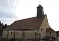 Kapelle Saint-Sulpice
Weblinks
Commons: Saint-Lubin-de-la-Haye – Sammlung von Bildern, Videos und Audiodateien
This article is issued from Wikipedia. The text is licensed under Creative Commons - Attribution - Sharealike. The authors of the article are listed here. Additional terms may apply for the media files, click on images to show image meta data.