Rueil-la-Gadelière
Rueil-la-Gadelière ist eine französische Gemeinde mit 498 Einwohnern (Stand 1. Januar 2019) im Département Eure-et-Loir in der Region Centre-Val de Loire; sie gehört zum Arrondissement Dreux und zum Kanton Saint-Lubin-des-Joncherets.
| Rueil-la-Gadelière | ||
|---|---|---|
| ||
| Staat | Frankreich | |
| Region | Centre-Val de Loire | |
| Département (Nr.) | Eure-et-Loir (28) | |
| Arrondissement | Dreux | |
| Kanton | Saint-Lubin-des-Joncherets | |
| Gemeindeverband | Agglo du Pays de Dreux | |
| Koordinaten | 48° 43′ N, 0° 59′ O | |
| Höhe | 147–192 m | |
| Fläche | 18,94 km² | |
| Einwohner | 498 (1. Januar 2019) | |
| Bevölkerungsdichte | 26 Einw./km² | |
| Postleitzahl | 28270 | |
| INSEE-Code | 28322 | |
Rueil-la-Gadelière wurde 1858 durch die Zusammenlegung der Orte Rueil und La Gadelière gebildet.
Hydrologie
Durch das Gemeindegebiet verläuft der Fluss Buternay, der an der nördlichen Grenze in die Avre mündet. Entlang des Buternay und seines Zuflusses Lamblore werden mehrere Quellen gefasst und im Avre-Aquädukt zur Trinkwasserversorgung nach Paris abgeleitet.
Bevölkerungsentwicklung
| Jahr | 1962 | 1968 | 1975 | 1982 | 1990 | 1999 | 2008 | 2014 |
| Einwohner | 246 | 311 | 305 | 406 | 455 | 476 | 464 | 533 |
Persönlichkeiten
- Maurice de Vlaminck (1876–1958), Maler, starb in Rueil-la-Gadelière

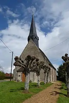
Kirche Saint-Denis
Weblinks
Commons: Rueil-la-Gadelière – Sammlung von Bildern, Videos und Audiodateien
This article is issued from Wikipedia. The text is licensed under Creative Commons - Attribution - Sharealike. The authors of the article are listed here. Additional terms may apply for the media files, click on images to show image meta data.
