La Mancelière
La Mancelière ist eine französische Gemeinde mit 178 Einwohnern (Stand: 1. Januar 2019) im Département Eure-et-Loir in der Region Centre-Val de Loire; sie gehört zum Arrondissement Dreux und ist Teil des Kantons Saint-Lubin-des-Joncherets (bis 2015: Kanton Brezolles).
| La Mancelière | ||
|---|---|---|
| ||
| Staat | Frankreich | |
| Region | Centre-Val de Loire | |
| Département (Nr.) | Eure-et-Loir (28) | |
| Arrondissement | Dreux | |
| Kanton | Saint-Lubin-des-Joncherets | |
| Gemeindeverband | Agglo du Pays de Dreux | |
| Koordinaten | 48° 39′ N, 1° 0′ O | |
| Höhe | 179–212 m | |
| Fläche | 5,92 km² | |
| Einwohner | 178 (1. Januar 2019) | |
| Bevölkerungsdichte | 30 Einw./km² | |
| Postleitzahl | 28270 | |
| INSEE-Code | 28231 | |
_Montmureau_mairie_Eure-et-Loir_France.jpg.webp) Mairie La Mancelière | ||

Geographie
La Mancelière liegt etwa 45 Kilometer nordwestlich von Chartres. Umgeben wird La Mancelière von den Nachbargemeinden Beauche im Norden, Les Châtelets im Osten und Nordosten, La Saucelle im Osten und Südosten, La Puisaye im Süden sowie Morvilliers im Westen.
Bevölkerungsentwicklung
| Jahr | 1962 | 1968 | 1975 | 1982 | 1990 | 1999 | 2006 | 2017 |
|---|---|---|---|---|---|---|---|---|
| Einwohner | 148 | 127 | 102 | 117 | 134 | 142 | 158 | 187 |
| Quellen: Cassini und INSEE | ||||||||
Sehenswürdigkeiten
- Kirche Notre-Dame
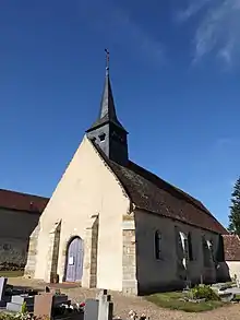
Kirche Notre-Dame
Weblinks
Commons: La Mancelière – Sammlung von Bildern, Videos und Audiodateien
This article is issued from Wikipedia. The text is licensed under Creative Commons - Attribution - Sharealike. The authors of the article are listed here. Additional terms may apply for the media files, click on images to show image meta data.