Alluy
Alluy ist eine französische Gemeinde mit 377 Einwohnern (Stand: 1. Januar 2019) im Département Nièvre in der Region Bourgogne-Franche-Comté (vor 2016 Bourgogne). Sie gehört zum Arrondissement Château-Chinon (Ville) und zum Kanton Château-Chinon (bis 2015 Châtillon-en-Bazois). Die Einwohner werden Alluysiens genannt.
| Alluy | ||
|---|---|---|
| ||
| Staat | Frankreich | |
| Region | Bourgogne-Franche-Comté | |
| Département (Nr.) | Nièvre (58) | |
| Arrondissement | Château-Chinon (Ville) | |
| Kanton | Château-Chinon | |
| Gemeindeverband | Bazois Loire Morvan | |
| Koordinaten | 47° 2′ N, 3° 39′ O | |
| Höhe | 221–287 m | |
| Fläche | 27,61 km² | |
| Einwohner | 377 (1. Januar 2019) | |
| Bevölkerungsdichte | 14 Einw./km² | |
| Postleitzahl | 58110 | |
| INSEE-Code | 58004 | |

Geographie
Alluy liegt etwa 38 Kilometer ostnordöstlich von Nevers. Umgeben wird Alluy von den Nachbargemeinden Châtillon-en-Bazois im Norden, Tamnay-en-Bazois im Nordosten, Brinay im Osten und Südosten, Biches im Süden, Tintury im Südwesten sowie Rouy im Westen.
Bevölkerungsentwicklung
| Jahr | 1962 | 1968 | 1975 | 1982 | 1990 | 1999 | 2006 | 2011 | 2016 |
| Einwohner | 560 | 526 | 521 | 443 | 449 | 403 | 423 | 408 | 389 |
| Quellen: Cassini und INSEE | |||||||||
Sehenswürdigkeiten
- Kirche Saint-Pierre-et-Saint-Paul aus dem 19. Jahrhundert
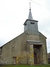
Kirche Saint-Pierre-et-Saint-Paul
Literatur
- Le Patrimoine des Communes de la Nièvre. Band 1, Flohic Editions, Charenton-le-Pont 1999, ISBN 2-84234-054-X, S. 205–208.
This article is issued from Wikipedia. The text is licensed under Creative Commons - Attribution - Sharealike. The authors of the article are listed here. Additional terms may apply for the media files, click on images to show image meta data.