Larochemillay
Larochemillay ist eine französische Gemeinde mit 231 Einwohnern (Stand: 1. Januar 2019) im Département Nièvre in der Region Bourgogne-Franche-Comté. Sie gehört zum Arrondissement Château-Chinon (Ville) und zum Kanton Luzy. Die Einwohner werden Millirupétiens genannt.
| Larochemillay | ||
|---|---|---|
| ||
| Staat | Frankreich | |
| Region | Bourgogne-Franche-Comté | |
| Département (Nr.) | Nièvre (58) | |
| Arrondissement | Château-Chinon (Ville) | |
| Kanton | Luzy | |
| Gemeindeverband | Bazois Loire Morvan | |
| Koordinaten | 46° 53′ N, 4° 0′ O | |
| Höhe | 282–780 m | |
| Fläche | 40,40 km² | |
| Einwohner | 231 (1. Januar 2019) | |
| Bevölkerungsdichte | 6 Einw./km² | |
| Postleitzahl | 58370 | |
| INSEE-Code | 58140 | |

Geographie
Larochemillay liegt etwa 62 Kilometer ostsüdöstlich von Nevers im Morvan. Das Gemeindegebiet wird vom kleinen Fluss Roche durchquert. Umgeben wird Larochemillay von den Nachbargemeinden Villapourçon im Norden und Nordwesten, Glux-en-Glenne im Norden und Nordosten, Saint-Léger-sous-Beuvray im Nordosten, Poil im Osten, Millay im Süden sowie Chiddes im Westen und Südwesten.
Bevölkerungsentwicklung
| Jahr | 1962 | 1968 | 1975 | 1982 | 1990 | 1999 | 2006 | 2011 | 2016 |
|---|---|---|---|---|---|---|---|---|---|
| Einwohner | 640 | 558 | 516 | 417 | 337 | 287 | 297 | 287 | 231 |
| Quellen: Cassini und INSEE | |||||||||
Sehenswürdigkeiten
- Kirche Saint-Pierre, Monument historique
- Schloss La Roche-Millay, seit 2002 Monument historique
- Mühle von Montécot
 Kirche Saint-Pierre
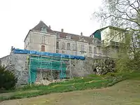 Schloss La Rochemillay
Literatur
- Le Patrimoine des Communes de la Nièvre. Band 2, Flohic Editions, Charenton-le-Pont 1999, ISBN 2-84234-054-X, S. 578–582.
This article is issued from Wikipedia. The text is licensed under Creative Commons - Attribution - Sharealike. The authors of the article are listed here. Additional terms may apply for the media files, click on images to show image meta data.