Yates County
Yates County[1] ist ein County im Bundesstaat New York der Vereinigten Staaten. Bei der Volkszählung im Jahr 2010 hatte das County 25.348 Einwohner und eine Bevölkerungsdichte von 28,9 Einwohnern pro Quadratkilometer. Der Verwaltungssitz (County Seat) ist Penn Yan.
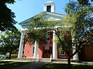 Courthouse im Yates County Courthouse Park District (2015). Dieser Historic District ist einer von 65 Einträgen für das County im National Register of Historic Places. | |
| Verwaltung | |
|---|---|
| US-Bundesstaat: | New York |
| Verwaltungssitz: | Penn Yan |
| Adresse des Verwaltungssitzes: |
417 Liberty St. Penn Yan, NY 14527 |
| Gründung: | 5. Februar 1823 |
| Gebildet aus: | Ontario County, Steuben County |
| Vorwahl: | 001 315 |
| Demographie | |
| Einwohner: | 25.348 (2010) |
| Bevölkerungsdichte: | 28,94 Einwohner/km2 |
| Geographie | |
| Fläche gesamt: | 973,3 km² |
| Wasserfläche: | 97,5 km² |
| Karte | |
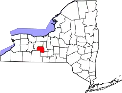 Karte von Yates County innerhalb von New York | |
Geographie
Das County hat eine Fläche von 973,3 Quadratkilometern, wovon 97,5 Quadratkilometer Wasserfläche sind.
.svg.png.webp)
Geschichte
Das County ist nach Joseph C. Yates benannt, einem ehemaligen Gouverneur von New York. Es wurde am 5. Februar 1823 gegründet.[2]
65 Bauwerke und Stätten des Countys sind insgesamt im National Register of Historic Places eingetragen (Stand 21. Februar 2018).[3]
Einwohnerentwicklung
| Jahr | 1800 | 1810 | 1820 | 1830 | 1840 | 1850 | 1860 | 1870 | 1880 | 1890 |
|---|---|---|---|---|---|---|---|---|---|---|
| Einwohner | – | – | – | 19.009 | 20.444 | 20.590 | 20.290 | 19.595 | 21.087 | 21.001 |
| Jahr | 1900 | 1910 | 1920 | 1930 | 1940 | 1950 | 1960 | 1970 | 1980 | 1990 |
| Einwohner | 20.318 | 18.642 | 16.641 | 16.848 | 16.381 | 17.615 | 18.614 | 19.831 | 21.459 | 22.810 |
| Jahr | 2000 | 2010 | 2020 | 2030 | 2040 | 2050 | 2060 | 2070 | 2080 | 2090 |
| Einwohner | 24.621 | 25.363 |
Städte und Ortschaften
Zusätzlich zu den unten angeführten selbständigen Gemeinden gibt es im ??? County mehrere villages.
| Ortschaft | Status | Einwohner (2010)[5] | Gesamte Fläche [km²][6] | Landfläche [km²]![6] | Bevölkerungsdichte [Einwohner / km²] | Gründung[7] | Besonderheit |
|---|---|---|---|---|---|---|---|
| Barrington | town | 1.681 | 96,2 | 92,6 | 18,2 | 6. Apr. 1822 | |
| Benton | town | 2.836 | 115,1 | 107,4 | 26,4 | 12. Feb. 1803 | Gründungsname: Vernon; umbenannt am 6. April 1808 in Shell, in Benton am 2. April 1810 |
| Italy | town | 1.141 | 104,3 | 104,0 | 11,0 | 15. Feb. 1815 | |
| Jerusalem | town | 4.469 | 169,4 | 151,9 | 29,4 | Jan. 1789 | |
| Middlesex | town | 1.495 | 88,3 | 80,0 | 18,7 | 1789 | Gründungsname: Augusta; umbenannt am 6. April 1808 |
| Milo | town | 7.006 | 114,8 | 99,5 | 70,4 | 6. März 1818 | |
| Potter | town | 1.865 | 96,4 | 96,4 | 19,3 | 26. Apr. 1832 | |
| Starkey | town | 3.573 | 101,5 | 85,0 | 42,0 | 6. Apr. 1824 | |
| Torrey | town | 1.282 | 87,2 | 58,9 | 21,8 | 11. Nov. 1851 |
Literatur
- John Homer French: Gazetteer of the State of New York. R.P Smith, Syracuse NY 1860, S. 717 ff. (Textarchiv – Internet Archive).
- Franklin Benjamin Hough: Gazetteer of the State of New York. Band 2. A. Boyd, Albany NY 1873, S. 718 ff. (Textarchiv – Internet Archive).
Weblinks
Einzelnachweise
- Yates County im Geographic Names Information System des United States Geological Survey
- Charles Curry Aiken, Joseph Nathan Kane: The American Counties: Origins of County Names, Dates of Creation, Area, and Population Data, 1950–2010. 6. Auflage. Scarecrow Press, Lanham 2013, ISBN 978-0-8108-8762-6, S. 429.
- Suchmaske Datenbank. National Register Information System, National Park Service; abgerufen am 21. Februar 2018.
- Einwohnerzahl 1830–2010 laut Volkszählungsergebnissen
- Einwohnerdaten aus dem US-Census von 2010. In: American Factfinder
- Offizielle Daten. United States Board on Geographic Names
- Franklin Benjamin Hough: Gazetteer of the State of New York. Band 2. A. Boyd, Albany NY 1873.
Liste der Countys in New York
Albany |
Allegany |
Bronx |
Broome |
Cattaraugus |
Cayuga |
Chautauqua |
Chemung |
Chenango |
Clinton |
Columbia |
Cortland |
Delaware |
Dutchess |
Erie |
Essex |
Franklin |
Fulton |
Genesee |
Greene |
Hamilton |
Herkimer |
Jefferson |
Kings (Brooklyn) |
Lewis |
Livingston |
Madison |
Monroe |
Montgomery |
Nassau |
New York (Manhattan) |
Niagara |
Oneida |
Onondaga |
Ontario |
Orange |
Orleans |
Oswego |
Otsego |
Putnam |
Queens |
Rensselaer |
Richmond (Staten Island) |
Rockland |
Saratoga |
Schenectady |
Schoharie |
Schuyler |
Seneca |
St. Lawrence |
Steuben |
Suffolk |
Sullivan |
Tioga |
Tompkins |
Ulster |
Warren |
Washington |
Wayne |
Westchester |
Wyoming |
Yates