Wayne County (New York)
Wayne County[1] ist ein County im Bundesstaat New York der Vereinigten Staaten. Bei der Volkszählung im Jahr 2020 hatte Wayne County 91.283 Einwohner und eine Bevölkerungsdichte von 58,4 Einwohnern pro Quadratkilometer.[2] Der Verwaltungssitz (County Seat) ist Lyons.
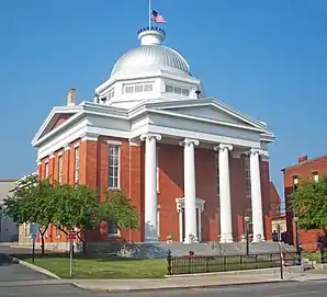 Wayne County Courthouse | |
| Verwaltung | |
|---|---|
| US-Bundesstaat: | New York |
| Verwaltungssitz: | Lyons |
| Gründung: | 11. April 1823 |
| Gebildet aus: | Ontario County Seneca County |
| Vorwahl: | 001 315 |
| Demographie | |
| Einwohner: | 91.283 (2020) |
| Bevölkerungsdichte: | 58,37 Einwohner/km2 |
| Geographie | |
| Fläche gesamt: | 3.582,1 km² |
| Wasserfläche: | 2.018,2 km² |
| Karte | |
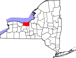 Karte von Wayne County innerhalb von New York | |
| Website: www.co.wayne.ny.us | |
Geographie
Das County hat eine Fläche von 3.582,1 Quadratkilometern, wovon 2.018,2 Quadratkilometer Wasserfläche sind.
Umliegende Gebiete
| Ontariosee | Ontariosee | Ontariosee |
| Monroe County | .svg.png.webp) |
Cayuga County |
| Ontario County | Ontario County Seneca County |
Cayuga County |
Geschichte
Das County wurde am 11. April 1823 und nach dem General Anthony Wayne benannt.[3]
Zwei Orte im County haben den Status einer National Historic Landmark, der Delaware and Hudson Canal und der New York State Barge Canal.[4] 35 Bauwerke und Stätten des Countys sind insgesamt im National Register of Historic Places eingetragen (Stand 21. Februar 2018).[5]
Einwohnerentwicklung
| Jahr | 1800 | 1810 | 1820 | 1830 | 1840 | 1850 | 1860 | 1870 | 1880 | 1890 |
|---|---|---|---|---|---|---|---|---|---|---|
| Einwohner | - | - | - | 33.643 | 42.057 | 44.953 | 47.762 | 47.710 | 51.700 | 49.729 |
| Jahr | 1900 | 1910 | 1920 | 1930 | 1940 | 1950 | 1960 | 1970 | 1980 | 1990 |
| Einwohner | 48.660 | 50.179 | 48.827 | 49.995 | 52.747 | 57.323 | 67.989 | 79.404 | 84.581 | 89.123 |
| Jahr | 2000 | 2010 | 2020 | 2030 | 2040 | 2050 | 2060 | 2070 | 2080 | 2090 |
| Einwohner | 93.765 | 93.751 | 91.283 |
Städte und Ortschaften
Zusätzlich zu den unten angeführten selbständigen Gemeinden gibt es im Wayne County mehrere villages.
| Ortschaft | Status | Einwohner (2010)[7] | Gesamte Fläche [km²][8] | Landfläche [km²][8] | Bevölkerungsdichte [Einwohner / km²] | Gründung[9] | Besonderheit |
|---|---|---|---|---|---|---|---|
| Arcadia | town | 14.244 | 135,1 | 134,8 | 273,7 | 15. Feb. 1825 | |
| Butler | town | 2.064 | 96,3 | 96,1 | 21,5 | 26. Feb. 1826 | |
| Galen | town | 4.290 | 155,5 | 154,0 | 27,9 | 14. Feb. 1812 | |
| Huron | town | 2.118 | 111,6 | 102,0 | 20,8 | 25. Feb. 1826 | Gegründet als Port Bay; umbenannt am 17. März 1834 |
| Lyons | town | 5.682 | 97,4 | 97,1 | 58,5 | 1. März 1811 | County Seat |
| Macedon | town | 9.148 | 100,6 | 100,2 | 91,3 | 29. Jan. 1823 | |
| Marion | town | 4.746 | 75,8 | 75,5 | 62,9 | 18. Apr. 1825 | Gegründet als Winchester; umbenannt am 15. April 1826 |
| Ontario | town | 10.136 | 84,2 | 83,9 | 120,8 | 27. März 1807 | Gegründet als Freedom; umbenannt am 12. Februar 1808 |
| Palmyra | town | 7.975 | 87,2 | 86,6 | 92,1 | Jan. 1789 | |
| Rose | town | 2.369 | 87,8 | 87,8 | 27,0 | 5. Feb. 1826 | |
| Savannah | town | 1.730 | 93,7 | 93,2 | 18,6 | 24. Nov. 1824 | |
| Sodus | town | 8.384 | 179,3 | 174,2 | 48,1 | Jan. 1789 | |
| Walworth | town | 9.449 | 87,8 | 87,7 | 107,7 | 20. Apr. 1829 | |
| Williamson | town | 6.984 | 89,8 | 89,7 | 77,9 | 20. Feb. 1802 | |
| Wolcott | town | 4.453 | 103,5 | 101,1 | 44,0 | 24. März 1807 |
Literatur
- Franklin Benjamin Hough: Gazetteer of the State of New York. Band 2. A. Boyd, Albany NY 1873, S. 690 ff. (englisch, Textarchiv – Internet Archive).
Weblinks
Einzelnachweise
- Wayne County im Geographic Names Information System des United States Geological Survey
- https://www.census.gov/quickfacts/fact/table/waynecountynewyork/SBO030212
- Charles Curry Aiken, Joseph Nathan Kane: The American Counties: Origins of County Names, Dates of Creation, Area, and Population Data, 1950–2010. 6. Auflage. Scarecrow Press, Lanham 2013, ISBN 978-0-8108-8762-6, S. 323.
- New York. (PDF) Listing of National Historic Landmarks by State, National Park Service; abgerufen am 21. Februar 2018.
- Suchmaske Datenbank. National Register Information System, National Park Service; abgerufen am 21. Februar 2018.
- Einwohnerzahl 1830–2010 laut Volkszählungsergebnissen
- Einwohnerdaten aus dem US-Census von 2010. In: American Factfinder
- Offizielle Daten. United States Board on Geographic Names
- Franklin Benjamin Hough: Gazetteer of the State of New York. Band 2. A. Boyd, Albany NY 1873, S. 692 ff. (englisch).
Liste der Countys in New York
Albany |
Allegany |
Bronx |
Broome |
Cattaraugus |
Cayuga |
Chautauqua |
Chemung |
Chenango |
Clinton |
Columbia |
Cortland |
Delaware |
Dutchess |
Erie |
Essex |
Franklin |
Fulton |
Genesee |
Greene |
Hamilton |
Herkimer |
Jefferson |
Kings (Brooklyn) |
Lewis |
Livingston |
Madison |
Monroe |
Montgomery |
Nassau |
New York (Manhattan) |
Niagara |
Oneida |
Onondaga |
Ontario |
Orange |
Orleans |
Oswego |
Otsego |
Putnam |
Queens |
Rensselaer |
Richmond (Staten Island) |
Rockland |
Saratoga |
Schenectady |
Schoharie |
Schuyler |
Seneca |
St. Lawrence |
Steuben |
Suffolk |
Sullivan |
Tioga |
Tompkins |
Ulster |
Warren |
Washington |
Wayne |
Westchester |
Wyoming |
Yates