Cortland County
Cortland County[1] ist ein County im Bundesstaat New York der Vereinigten Staaten. Bei der Volkszählung im Jahr 2010 hatte das County 49.336 Einwohner und eine Bevölkerungsdichte von 38,2 Einwohnern pro Quadratkilometer. Der Verwaltungssitz (County Seat) ist Cortland.
%252C_Cortland%252C_New_York.jpg.webp) Cortland County Courthouse | |
| Verwaltung | |
|---|---|
| US-Bundesstaat: | New York |
| Verwaltungssitz: | Cortland |
| Gründung: | 1808 |
| Gebildet aus: | Onondaga County |
| Vorwahl: | 001 607 |
| Demographie | |
| Einwohner: | 49.336 (2010) |
| Bevölkerungsdichte: | 38,19 Einwohner/km2 |
| Geographie | |
| Fläche gesamt: | 1.298,9 km² |
| Wasserfläche: | 7,1 km² |
| Karte | |
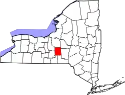 Karte von Cortland County innerhalb von New York | |
| Website: www.cortland-co.org | |
Geschichte
28 Bauwerke und Stätten des Countys sind im National Register of Historic Places eingetragen (Stand 18. Februar 2018).[2]
Einwohnerentwicklung
| Jahr | 1800 | 1810 | 1820 | 1830 | 1840 | 1850 | 1860 | 1870 | 1880 | 1890 |
|---|---|---|---|---|---|---|---|---|---|---|
| Einwohner | – | 8869 | 16.507 | 23.791 | 24.607 | 25.140 | 26.294 | 25.173 | 25.825 | 28.657 |
| Jahr | 1900 | 1910 | 1920 | 1930 | 1940 | 1950 | 1960 | 1970 | 1980 | 1990 |
| Einwohner | 27.576 | 29.249 | 29.625 | 31.709 | 33.668 | 37.158 | 41.113 | 45.894 | 48.820 | 48.963 |
| Jahr | 2000 | 2010 | 2020 | 2030 | 2040 | 2050 | 2060 | 2070 | 2080 | 2090 |
| Einwohner | 48.599 | 49.336 |
Hinweis: Der Wert von 1810 ist lediglich aus der englischsprachigen Wikipedia ungeprüft übernommen worden, weil die Einwohnerzahlen für 1810 derzeit auf dem Server der Census-Behörde nicht verfügbar sind. (Stand: 21. Oktober 2020)
Geographie
Das County hat eine Fläche von 1.298,9 Quadratkilometern, wovon 7,1 Quadratkilometer Wasserfläche sind.
.svg.png.webp)
Städte und Ortschaften
Zusätzlich zu den unten angeführten selbständigen Gemeinden gibt es im Cortland County mehrere villages.
| Ortschaft | Status | Einwohner (2010)![4] | Gesamte Fläche [km²]![5] | Landfläche [km²]![5] | Bevölkerungsdichte [Einwohner / km²] | Gründung[6] | Besonderheit |
|---|---|---|---|---|---|---|---|
| Cincinnatus | town | 1.056 | 66,0 | 65,7 | 16,1 | 3. Apr. 1804 | |
| Cortland | city | 7.433 | 10,1 | 10,1 | 735,9 | 1791 als City: 1900 |
County Seat |
| Cortlandville | town | 8.509 | 129,9 | 128,8 | 66,1 | 11. Apr. 1829 | |
| Cuyler | town | 980 | 112,7 | 112,6 | 8,7 | 18. Nov. 1828 | |
| Freetown | town | 757 | 66,4 | 66,0 | 11,5 | 21. Apr. 1818 | |
| Harford | town | 943 | 62,6 | 62,6 | 15,1 | 2. Mai 1845 | |
| Homer | town | 6.405 | 131,2 | 130,0 | 49,3 | 5. März 1794 | |
| Lapeer | town | 767 | 65,2 | 64,9 | 11,8 | 2. Mai 1845 | |
| Marathon | town | 1.967 | 64,9 | 64,6 | 30,3 | 21. Apr. 1818 | |
| Preble | town | 1.393 | 71,4 | 69,5 | 20,0 | 8. Apr. 1808 | |
| Scott | town | 1.176 | 58,1 | 57,7 | 20,4 | 14. Apr. 1815 | |
| Solon | town | 1.079 | 77,0 | 76,8 | 14,0 | 9. März 1798 | |
| Taylor | town | 523 | 78,0 | 77,7 | 6,7 | 5. Dez. 1849 | |
| Truxton | town | 1.133 | 115,8 | 115,6 | 9,8 | 8. Apr. 1808 | |
| Virgil | town | 2.401 | 122,8 | 122,7 | 19,6 | 3. Apr. 1804 | |
| Willet | town | 1.043 | 67,5 | 66,6 | 15,7 | 21. Apr. 1818 |
Literatur
- Henry Perry Smith: History of Cortland County. D.Mason & Co, Syracuse NY 1885, S. 552 (archive.org).
- H.C. Goodwin: Pioneer history; or, Cortland County and the border wars of New York. A.B. Burdick, New York 1859 (archive.org).
Weblinks
Einzelnachweise
- Cortland County im Geographic Names Information System des United States Geological Survey
- Suchmaske Datenbank im National Register Information System. National Park Service, abgerufen am 18. Februar 2018.
- Einwohnerzahl 1790–2010 laut Volkszählungsergebnissen
- Einwohnerdaten aus dem US-Census von 2010. In: American Factfinder
- Offizielle Daten. United States Board on Geographic Names
- Franklin Benjamin Hough: Gazetteer of the State of New York. Band 1. A. Boyd, Albany NY 1873, S. 250 ff.
Liste der Countys in New York
Albany |
Allegany |
Bronx |
Broome |
Cattaraugus |
Cayuga |
Chautauqua |
Chemung |
Chenango |
Clinton |
Columbia |
Cortland |
Delaware |
Dutchess |
Erie |
Essex |
Franklin |
Fulton |
Genesee |
Greene |
Hamilton |
Herkimer |
Jefferson |
Kings (Brooklyn) |
Lewis |
Livingston |
Madison |
Monroe |
Montgomery |
Nassau |
New York (Manhattan) |
Niagara |
Oneida |
Onondaga |
Ontario |
Orange |
Orleans |
Oswego |
Otsego |
Putnam |
Queens |
Rensselaer |
Richmond (Staten Island) |
Rockland |
Saratoga |
Schenectady |
Schoharie |
Schuyler |
Seneca |
St. Lawrence |
Steuben |
Suffolk |
Sullivan |
Tioga |
Tompkins |
Ulster |
Warren |
Washington |
Wayne |
Westchester |
Wyoming |
Yates