Chenango County
Chenango County[1] ist ein County im Bundesstaat New York der Vereinigten Staaten. Bei der Volkszählung im Jahr 2020 hatte das County 47.220 Einwohner und eine Bevölkerungsdichte von 20,4 Einwohnern pro Quadratkilometer.[2] Der Verwaltungssitz (County Seat) ist Norwich.
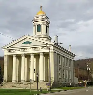 Das Chenango County Courthouse (2011) liegt im gleichnamigen Historic District | |
| Verwaltung | |
|---|---|
| US-Bundesstaat: | New York |
| Verwaltungssitz: | Norwich |
| Gründung: | 15. März 1798 |
| Gebildet aus: | Tioga County |
| Vorwahl: | 001 607 |
| Demographie | |
| Einwohner: | 47.220 (2020) |
| Bevölkerungsdichte: | 20,41 Einwohner/km2 |
| Geographie | |
| Fläche gesamt: | 2327 km² |
| Wasserfläche: | 13,2 km² |
| Karte | |
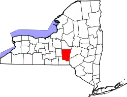 Karte von Chenango County innerhalb von New York | |
| Website: www.co.chenango.ny.us | |
Geographie
Das County hat eine Fläche von 2.327,2 Quadratkilometern, wovon 13,2 Quadratkilometer Wasserfläche sind.
.svg.png.webp)
Geschichte
41 Bauwerke und Stätten des Countys sind im National Register of Historic Places eingetragen (Stand 18. Februar 2018).[3]
Einwohnerentwicklung
| Jahr | 1800 | 1810 | 1820 | 1830 | 1840 | 1850 | 1860 | 1870 | 1880 | 1890 |
|---|---|---|---|---|---|---|---|---|---|---|
| Einwohner | 15.666 | 21.704 | 31.215 | 37.238 | 40.785 | 40.311 | 40.934 | 40.564 | 39.891 | 37.776 |
| Jahr | 1900 | 1910 | 1920 | 1930 | 1940 | 1950 | 1960 | 1970 | 1980 | 1990 |
| Einwohner | 36.568 | 35.575 | 34.969 | 34.665 | 36.454 | 39.138 | 43.243 | 46.243 | 49.344 | 51.768 |
| Jahr | 2000 | 2010 | 2020 | 2030 | 2040 | 2050 | 2060 | 2070 | 2080 | 2090 |
| Einwohner | 51.401 | 50.477 | 47.220 |
Hinweis: Der Wert von 1810 ist lediglich aus der englischsprachigen Wikipedia ungeprüft übernommen worden, weil die Einwohnerzahlen für 1810 derzeit auf dem Server der Census-Behörde nicht verfügbar sind. (Stand: 22. Oktober 2020)
Städte und Ortschaften
Zusätzlich zu den unten angeführten selbständigen Gemeinden gibt es im Chenango County mehrere villages.
| Ortschaft | Status | Einwohner (2010)[5] | Gesamte Fläche [km²] | [6] Landfläche [km²] | [6] Bevölkerungsdichte [Einwohner/km²] | Gründung[7] | Besonderheit |
|---|---|---|---|---|---|---|---|
| Afton | town | 2.581 | 120,5 | 118,7 | 21,7 | 18. Nov. 1857 | |
| Bainbridge | town | 3.308 | 90,0 | 88,9 | 37,2 | 16. Feb. 1791 | Gründungsname „Jericho“; umbenannt am 15. April 1814 |
| Columbus | town | 975 | 97,1 | 96,8 | 10,1 | 11. Feb. 1805 | |
| Coventry | town | 1.655 | 126,6 | 126,1 | 13,1 | 7. Feb. 1806 | |
| German | town | 370 | 73,7 | 73,6 | 5,0 | 21. März 1806 | |
| Greene | town | 5.604 | 195,9 | 194,4 | 28,8 | 15. März 1798 | |
| Guilford | town | 2.922 | 160,5 | 159,8 | 18,3 | 3. Apr. 1813 | Gründungsname „Eastern“; umbenannt am 21. März 1817 |
| Lincklaen | town | 396 | 68,0 | 68,0 | 5,8 | 12. Apr. 1823 | |
| McDonough | town | 886 | 102,6 | 101,1 | 8,8 | 17. Apr. 1816 | |
| New Berlin | town | 2.682 | 120,6 | 119,5 | 22,4 | 3. Apr. 1807 | Name zwischen 9. Mai 1821 und 22. März 1822 „Lancaster“ |
| North Norwich | town | 1.783 | 73,2 | 72,9 | 24,5 | 7. Apr. 1849 | |
| Norwich City | city | 7.190 | 5,5 | 5,5 | 1.307,3 | 17. Apr. 1816 | Gründungsdatum als Village, zur City ernannt 1914 |
| Norwich Town | town | 3.998 | 108,9 | 108,7 | 36,8 | 19. Jan. 1793 | |
| Otselic | town | 1.054 | 98,5 | 98,4 | 10,7 | 28. März 1817 | |
| Oxford | town | 3.901 | 156,5 | 155,6 | 25,1 | 19. Jan. 1793 | |
| Pharsalia | town | 593 | 101,3 | 100,5 | 5,9 | 7. Apr. 1806 | Gründungsname „Stonington“; umbenannt am 6. April 1808 |
| Pitcher | town | 803 | 73,8 | 73,7 | 10,9 | 13. Feb. 1827 | |
| Plymouth | town | 1.804 | 109,7 | 109,2 | 16,5 | 7. Apr. 1806 | |
| Preston | town | 1.044 | 90,8 | 90,3 | 11,6 | 2. Apr. 1806 | |
| Sherburne | town | 4.048 | 112,9 | 112,8 | 35,9 | 5. März 1795 | |
| Smithville | town | 1.330 | 131,9 | 130,7 | 10,2 | 1. Apr. 1808 | |
| Smyrna | town | 1.280 | 109,2 | 109,0 | 11,7 | 25. März 1808 | Gründungsname „Stafford“; umbenannt am 6. April 1808 |
Literatur
- John Homer French: Gazetteer of the State of New York. R.P Smith, Syracuse NY 1860 (archive.org).
- Hiram C. Clark: History of Chenango county, containing the divisions of the county and sketches of the towns; Indian tribes and titles. Thompson & Pratt, Norwich NY 1850 (archive.org).
Weblinks
Einzelnachweise
- Chenango County im Geographic Names Information System des United States Geological Survey, abgerufen am 22. Oktober 2020.
- https://www.census.gov/quickfacts/fact/table/chenangocountynewyork/SBO030212
- Suchmaske Datenbank. In: National Register Information System. National Park Service, abgerufen am 18. Februar 2018.
- Einwohnerzahl 1800–2010 laut Volkszählungsergebnissen
- Einwohnerdaten aus dem US-Census von 2010. In: American Factfinder
- Offizielle Daten des United States Board on Geographic Names
- Franklin Benjamin Hough: Gazetteer of the State of New York. Band 1. A. Boyd, Albany NY 1873, S. 216 ff.
Liste der Countys in New York
Albany |
Allegany |
Bronx |
Broome |
Cattaraugus |
Cayuga |
Chautauqua |
Chemung |
Chenango |
Clinton |
Columbia |
Cortland |
Delaware |
Dutchess |
Erie |
Essex |
Franklin |
Fulton |
Genesee |
Greene |
Hamilton |
Herkimer |
Jefferson |
Kings (Brooklyn) |
Lewis |
Livingston |
Madison |
Monroe |
Montgomery |
Nassau |
New York (Manhattan) |
Niagara |
Oneida |
Onondaga |
Ontario |
Orange |
Orleans |
Oswego |
Otsego |
Putnam |
Queens |
Rensselaer |
Richmond (Staten Island) |
Rockland |
Saratoga |
Schenectady |
Schoharie |
Schuyler |
Seneca |
St. Lawrence |
Steuben |
Suffolk |
Sullivan |
Tioga |
Tompkins |
Ulster |
Warren |
Washington |
Wayne |
Westchester |
Wyoming |
Yates