Delaware County (New York)
Delaware County[1] ist ein County im Bundesstaat New York der Vereinigten Staaten. Bei der Volkszählung im Jahr 2010 hatte das County 47.980 Einwohner und eine Bevölkerungsdichte von 13,1 Einwohnern pro Quadratkilometer. Der Verwaltungssitz (County Seat) ist Delhi.
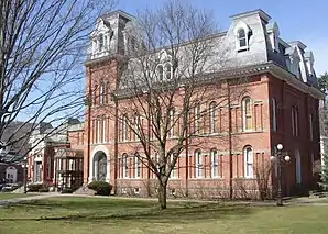 Delaware County Courthouse | |
| Verwaltung | |
|---|---|
| US-Bundesstaat: | New York |
| Verwaltungssitz: | Delhi |
| Gründung: | 10. März 1797 |
| Gebildet aus: | Otsego County Ulster County |
| Vorwahl: | 001 607 |
| Demographie | |
| Einwohner: | 47.980 (2010) |
| Bevölkerungsdichte: | 13,07 Einwohner/km2 |
| Geographie | |
| Fläche gesamt: | 3.735,9 km² |
| Wasserfläche: | 64,8 km² |
| Karte | |
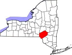 Karte von Delaware County innerhalb von New York | |
| Website: www.co.delaware.ny.us | |
Geographie
Das County hat eine Fläche von 3.735,9 Quadratkilometern, wovon 64,8 Quadratkilometer Wasserfläche sind.
.svg.png.webp)
Geschichte
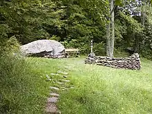
Ein Ort hat den Status einer National Historic Landmark, die Woodchuck Lodge.[2] 65 Bauwerke und Stätten des Countys sind insgesamt im National Register of Historic Places eingetragen (Stand 18. Februar 2018).[3]
Einwohnerentwicklung
| Jahr | 1800 | 1810 | 1820 | 1830 | 1840 | 1850 | 1860 | 1870 | 1880 | 1890 |
|---|---|---|---|---|---|---|---|---|---|---|
| Einwohner | 10.228 | 20.303 | 26.587 | 33.024 | 35.396 | 39.834 | 42.465 | 42.972 | 42.721 | 45.496 |
| Jahr | 1900 | 1910 | 1920 | 1930 | 1940 | 1950 | 1960 | 1970 | 1980 | 1990 |
| Einwohner | 46.413 | 45.575 | 42.774 | 41.163 | 40.989 | 44.420 | 43.540 | 44.718 | 46.824 | 47.225 |
| Jahr | 2000 | 2010 | 2020 | 2030 | 2040 | 2050 | 2060 | 2070 | 2080 | 2090 |
| Einwohner | 48.055 | 47.980 |
Hinweis: Der Wert von 1810 ist lediglich aus der englischsprachigen Wikipedia ungeprüft übernommen worden, weil die Einwohnerzahlen für 1810 derzeit auf dem Server der Census-Behörde nicht verfügbar sind. (Stand: 1. November 2020)
Städte und Ortschaften
Zusätzlich zu den unten angeführten selbständigen Gemeinden gibt es im Delaware County mehrere villages und census-designated places.
| Ortschaft | Status | Einwohner (2010)[5] | Gesamte Fläche [km²][6] | Landfläche [km²][6] | Bevölkerungsdichte [Einwohner / km²] | Gründung[7] | Besonderheit |
|---|---|---|---|---|---|---|---|
| Andes | town | 1.301 | 290,8 | 281,3 | 4,6 | 13. Apr. 1819 | |
| Bovina | town | 633 | 115,2 | 114,6 | 5,5 | 25. Feb. 1829 | |
| Colchester | town | 2.077 | 368,2 | 354,3 | 5,9 | 10. Apr. 1792 | |
| Davenport | town | 2.965 | 134,5 | 133,5 | 22,2 | 31. März 1817 | |
| Delhi | town | 5.117 | 167,3 | 166,3 | 30,8 | 23. März 1798 | County Seat |
| Deposit | town | 1.712 | 115,5 | 111,4 | 15,4 | 5. Apr. 1811 | zur eigenständigen Town ernannt: 1880; zuvor village |
| Franklin | town | 2.411 | 211,2 | 210,4 | 11,5 | 10. Apr. 1792 | |
| Hamden | town | 1.323 | 155,9 | 155,2 | 8,5 | 4. Apr. 1825 | Gründungsname: Hampden; umbenannt 17. März 1826 |
| Hancock | town | 3.224 | 419,1 | 411,3 | 7,8 | 28. März 1806 | |
| Harpersfield | town | 1.577 | 109,5 | 108,8 | 14,5 | 7. März 1788 | |
| Kortright | town | 1.675 | 162,2 | 161,7 | 10,4 | 12. März 1793 | |
| Masonville | town | 1.320 | 141,0 | 140,5 | 9,4 | 4. Apr. 1811 | |
| Meredith | town | 1.529 | 151,0 | 150,5 | 10,2 | 14. März 1800 | |
| Middletown | town | 3.750 | 252,0 | 250,4 | 15,0 | 3. März 1789 | |
| Roxbury | town | 2.502 | 226,9 | 225,6 | 11,1 | 23. März 1799 | |
| Sidney | town | 5.774 | 131,1 | 129,3 | 44,7 | 7. Apr. 1801 | |
| Stamford | town | 2.267 | 125,9 | 125,6 | 18,0 | 10. Apr. 1792 | |
| Tompkins | town | 1.247 | 270,5 | 254,2 | 4,9 | 28. Feb. 1806 | Gründungsname: Pinefield; umbenannt 11. März 1808 |
| Walton | town | 5.576 | 252,8 | 250,8 | 22,2 | 17. März 1797 |
Phantasiestadt
Im County liegt Agloe, eine Papertown. Agloe spielt eine wichtige Rolle in Margos Spuren.
Literatur
- John Homer French: Gazetteer of the State of New York. R.P Smith, Syracuse NY 1860, S. 257 ff. (Textarchiv – Internet Archive).
- Franklin Benjamin Hough: Gazetteer of the State of New York. Band 1. A. Boyd, Albany NY 1873, S. 248 ff. (archive.org).
Weblinks
Einzelnachweise
- Delaware County (New York) (Englisch) In: Geographic Names Information System. United States Geological Survey. Abgerufen am 22. Februar 2011.
- New York. (PDF) Listing of National Historic Landmarks by State, National Park Service; abgerufen am 18. Februar 2018.
- Suchmaske Datenbank. National Register Information System, National Park Service; abgerufen am 18. Februar 2018.
- Einwohnerzahl 1800–2010 laut Volkszählungsergebnissen
- Einwohnerdaten aus dem US-Census von 2010. In: American Factfinder
- Offizielle Daten. United States Board on Geographic Names
- Franklin Benjamin Hough: Gazetteer of the State of New York. Band 1. A. Boyd, Albany NY 1873, S. 251 ff.
Liste der Countys in New York
Albany |
Allegany |
Bronx |
Broome |
Cattaraugus |
Cayuga |
Chautauqua |
Chemung |
Chenango |
Clinton |
Columbia |
Cortland |
Delaware |
Dutchess |
Erie |
Essex |
Franklin |
Fulton |
Genesee |
Greene |
Hamilton |
Herkimer |
Jefferson |
Kings (Brooklyn) |
Lewis |
Livingston |
Madison |
Monroe |
Montgomery |
Nassau |
New York (Manhattan) |
Niagara |
Oneida |
Onondaga |
Ontario |
Orange |
Orleans |
Oswego |
Otsego |
Putnam |
Queens |
Rensselaer |
Richmond (Staten Island) |
Rockland |
Saratoga |
Schenectady |
Schoharie |
Schuyler |
Seneca |
St. Lawrence |
Steuben |
Suffolk |
Sullivan |
Tioga |
Tompkins |
Ulster |
Warren |
Washington |
Wayne |
Westchester |
Wyoming |
Yates
| Stadt |
Andes | Bovina | Colchester | Davenport | Delhi | Deposit | Franklin | Hamden | Hancock | Harpersfield | Kortright | Masonville | Meredith | Middletown | Roxbury | Sidney | Stamford | Tompkins | Walton |
|
| Villages |
Delhi | Deposit | Fleischmanns | Franklin | Hancock | Hobart | Margaretville | Sidney | Stamford | Walton | |
| Census-designated places (CDP) |
Andes | Bloomville | Davenport Center | Downsville | |
| Weitere Siedlungen |
Agloe | Arena | Arkville | Barbourville | Bedell | Butternut Grove | China | Cooks Falls | Delancey | Denver | East Branch | East Meredith | Fishs Eddy | Grand Gorge | Gregorytown | Halcottsville | Hale Eddy | Hambletville | Horton | Islamberg | Loomis | Meridale | New Kingston | Rock Rift | Shinhopple | Sidney Center | South Kortright | Treadwell | Trout Creek | Upper Barbourville | West Davenport |