Otsego County (New York)
Otsego County[1] ist ein County im Bundesstaat New York der Vereinigten Staaten. Bei der Volkszählung im Jahr 2020 hatte das County 58.524 Einwohner und eine Bevölkerungsdichte von 22,6 Einwohner pro Quadratkilometer.[2] Der Verwaltungssitz (County Seat) ist Cooperstown am Otsego Lake, das die Baseball Hall of Fame beheimatet.
 Otsego County Courthouse | |
| Verwaltung | |
|---|---|
| US-Bundesstaat: | New York |
| Verwaltungssitz: | Cooperstown |
| Adresse des Verwaltungssitzes: |
County Office Building 197 Main Street Cooperstown, NY 13326 |
| Gründung: | 16. Februar 1791 |
| Gebildet aus: | Montgomery County |
| Vorwahl: | 001 607 |
| Demographie | |
| Einwohner: | 58.524 (2020) |
| Bevölkerungsdichte: | 22,56 Einwohner/km2 |
| Geographie | |
| Fläche gesamt: | 2.630,8 km² |
| Wasserfläche: | 36,4 km² |
| Karte | |
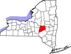 Karte von Otsego County innerhalb von New York | |
| Website: www.otsegocounty.com | |
Der Name Otsego leitet sich von einem indianischen Wort mit der Bedeutung Platz des Felsens ab.
Geographie
Das County hat eine Fläche von 2.630,8 Quadratkilometern, wovon 36,4 Quadratkilometer Wasserfläche sind.
.svg.png.webp)
Geschichte
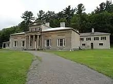
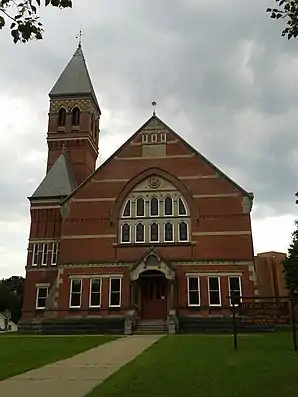
Ein Ort hat den Status einer National Historic Landmark, die Hyde Hall.[3] 71 Bauwerke und Stätten des Countys sind insgesamt im National Register of Historic Places eingetragen (Stand 20. Februar 2018).[4]
Einwohnerentwicklung
| Jahr | 1800 | 1810 | 1820 | 1830 | 1840 | 1850 | 1860 | 1870 | 1880 | 1890 |
|---|---|---|---|---|---|---|---|---|---|---|
| Einwohner | 21.343 | 38.802 | 44.856 | 51.372 | 49.628 | 48.638 | 50.157 | 48.967 | 51.397 | 50.861 |
| Jahr | 1900 | 1910 | 1920 | 1930 | 1940 | 1950 | 1960 | 1970 | 1980 | 1990 |
| Einwohner | 48.939 | 47.216 | 46.200 | 46.710 | 46.082 | 50.763 | 51.942 | 56.181 | 59.075 | 60.517 |
| Jahr | 2000 | 2010 | 2020 | 2030 | 2040 | 2050 | 2060 | 2070 | 2080 | 2090 |
| Einwohner | 61.676 | 62.259 | 58.524 |
Hinweis: Der Wert von 1810 ist lediglich aus der englischsprachigen Wikipedia ungeprüft übernommen worden, weil die Einwohnerzahlen für 1810 derzeit auf dem Server der Census-Behörde nicht verfügbar sind. (Stand: 23. Oktober 2020)
Städte und Ortschaften
Zusätzlich zu den unten angeführten selbständigen Gemeinden gibt es im Otsego County mehrere villages.
| Ortschaft | Status | Einwohner (2010)[6] | Gesamte Fläche [km²][7] | Landfläche [km²][7] | Bevölkerungsdichte [Einwohner / km²] | Gründung[8] | Besonderheit |
|---|---|---|---|---|---|---|---|
| Burlington | town | 1.140 | 116,6 | 116,3 | 9,8 | 10. Apr. 1792 | |
| Butternuts | town | 1.012 | 139,5 | 139,4 | 7,3 | 5. Feb. 1796 | |
| Cherry Valley | town | 1.223 | 104,6 | 104,6 | 11,7 | 16. Feb. 1791 | |
| Decatur | town | 353 | 53,8 | 53,3 | 6,6 | 25. März 1808 | |
| Edmeston | town | 1.826 | 114,9 | 114,7 | 15,9 | 1. Apr. 1808 | |
| Exeter | town | 987 | 84,7 | 83,1 | 11,9 | 25. März 1799 | |
| Hartwick | town | 2.110 | 104,7 | 103,8 | 20,3 | 30. März 1802 | |
| Laurens | town | 2.424 | 109,2 | 108,9 | 57,6 | 2. Apr. 1810 | |
| Maryland | town | 1.897 | 136,1 | 135,7 | 14,0 | 25. März 1808 | |
| Middlefield | town | 2.114 | 165,0 | 164,0 | 12,9 | 3. März 1797 | |
| Milford | town | 3.044 | 122,1 | 122,0 | 25,0 | 5. Feb. 1796 | Gründungsname: „Suffrage“; umbenannt am 8. April 1800 |
| Morris | town | 1.878 | 101,5 | 101,2 | 18,6 | 6. Apr. 1849 | |
| New Lisbon | town | 1.114 | 115,7 | 114,9 | 9,7 | 7. Apr. 1806 | Gründungsname: „Lisbon“; umbenannt am 6. April 1808 |
| Oneonta | city | 13.901 | 11,3 | 11,3 | 1230,2 | 14. Okt. 1848 | Zur city ernannt am 27. April 1870 |
| Oneonta | town | 5.229 | 85,9 | 85,2 | 61,4 | 5. Feb. 1796 | Gründungsname: „Otego“; umbenannt am 17. April 1830 |
| Otego | town | 3.115 | 118,4 | 118,2 | 26,4 | 12. Apr. 1822 | Gründungsname: „Huntsville“; umbenannt am 17. April 1830 |
| Otsego | town | 3.900 | 152,9 | 139,6 | 27,9 | 7. März 1788 | |
| Pittsfield | town | 1.366 | 98,7 | 98,4 | 13,9 | 24. März 1797 | |
| Plainfield | town | 915 | 76,4 | 76,4 | 12,0 | 25. März 1799 | |
| Richfield | town | 2.388 | 84,1 | 79,9 | 29,9 | 10. Apr. 1792 | |
| Roseboom | town | 711 | 86,8 | 86,5 | 8,2 | 23. Nov. 1854 | |
| Springfield | town | 1.358 | 117,9 | 111,1 | 12,2 | 3. März 1797 | |
| Unadilla | town | 4.392 | 120,9 | 119,8 | 36,7 | 10. Apr. 1792 | |
| Westford | town | 868 | 87,8 | 87,7 | 9,9 | 25. März 1808 | |
| Worcester | town | 2.220 | 121,4 | 121,4 | 18,3 | 3. März 1797 |
Literatur
- Franklin Benjamin Hough: Gazetteer of the State of New York. Band 2. A. Boyd, Albany NY 1873, S. 531 ff. (Textarchiv – Internet Archive).
- L. H. Butterfield: COOPER’S INHERITANCE: THE OTSEGO COUNTRY AND ITS FOUNDERS. New York History, 35(4), S. 374–411 (JSTOR)
Weblinks
Einzelnachweise
- Otsego County (New York) (Englisch) In: Geographic Names Information System. United States Geological Survey. Abgerufen am 23. Februar 2011.
- https://www.census.gov/quickfacts/fact/table/otsegocountynewyork/SBO030212
- New York. (PDF) Listing of National Historic Landmarks by State, National Park Service; abgerufen am 20. Februar 2018.
- Suchmaske Datenbank. National Register Information System, National Park Service; abgerufen am 20. Februar 2018.
- Einwohnerzahl 1800–2010 laut Volkszählungsergebnissen
- Einwohnerdaten aus dem US-Census von 2010. In: American Factfinder
- Offizielle Daten. United States Board on Geographic Names
- Franklin Benjamin Hough: Gazetteer of the State of New York. Band 2. A. Boyd, Albany NY 1873, S. 533 ff.
Liste der Countys in New York
Albany |
Allegany |
Bronx |
Broome |
Cattaraugus |
Cayuga |
Chautauqua |
Chemung |
Chenango |
Clinton |
Columbia |
Cortland |
Delaware |
Dutchess |
Erie |
Essex |
Franklin |
Fulton |
Genesee |
Greene |
Hamilton |
Herkimer |
Jefferson |
Kings (Brooklyn) |
Lewis |
Livingston |
Madison |
Monroe |
Montgomery |
Nassau |
New York (Manhattan) |
Niagara |
Oneida |
Onondaga |
Ontario |
Orange |
Orleans |
Oswego |
Otsego |
Putnam |
Queens |
Rensselaer |
Richmond (Staten Island) |
Rockland |
Saratoga |
Schenectady |
Schoharie |
Schuyler |
Seneca |
St. Lawrence |
Steuben |
Suffolk |
Sullivan |
Tioga |
Tompkins |
Ulster |
Warren |
Washington |
Wayne |
Westchester |
Wyoming |
Yates