Sullivan County (New York)
Sullivan County[1] ist ein County im Bundesstaat New York der Vereinigten Staaten. Bei der Volkszählung im Jahr 2010 hatte das County 77.547 Einwohner und eine Bevölkerungsdichte von 30,9 Einwohner pro Quadratkilometer. Der Verwaltungssitz (County Seat) ist Monticello.
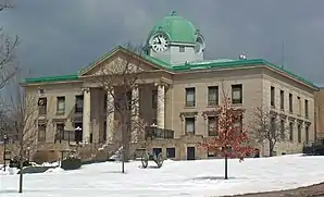 Sullivan County Courthouse | |
| Verwaltung | |
|---|---|
| US-Bundesstaat: | New York |
| Verwaltungssitz: | Monticello |
| Adresse des Verwaltungssitzes: |
3 East Pulteney Square Bath, NY 14810 |
| Gründung: | 27. März 1809 |
| Gebildet aus: | Ulster County |
| Demographie | |
| Einwohner: | 77.547 (2010) |
| Bevölkerungsdichte: | 30,93 Einwohner/km2 |
| Geographie | |
| Fläche gesamt: | 2.581,5 km² |
| Wasserfläche: | 74,1 km² |
| Karte | |
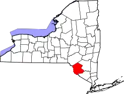 Karte von Sullivan County innerhalb von New York | |
| Website: www.co.sullivan.ny.us | |
Geographie
Das County hat eine Fläche von 2.581,5 Quadratkilometern, wovon 74,1 Quadratkilometer Wasserfläche sind.
.svg.png.webp)
Geschichte
Das County ist nach dem General des Unabhängigkeitskrieges John Sullivan benannt.
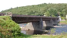
Ein Ort im County hat den Status einer National Historic Landmark, der Delaware and Hudson Canal.[2] 71 Bauwerke und Stätten des Countys sind insgesamt im National Register of Historic Places eingetragen (Stand 21. Februar 2018).[3]
Einwohnerentwicklung
| Jahr | 1800 | 1810 | 1820 | 1830 | 1840 | 1850 | 1860 | 1870 | 1880 | 1890 |
|---|---|---|---|---|---|---|---|---|---|---|
| Einwohner | – | 6108 | 8900 | 12.364 | 15.629 | 25.088 | 32.385 | 34.550 | 32.491 | 31.031 |
| Jahr | 1900 | 1910 | 1920 | 1930 | 1940 | 1950 | 1960 | 1970 | 1980 | 1990 |
| Einwohner | 32.306 | 33.808 | 33.163 | 35.272 | 37.901 | 40.731 | 45.272 | 52.580 | 65.155 | 69.277 |
| Jahr | 2000 | 2010 | 2020 | 2030 | 2040 | 2050 | 2060 | 2070 | 2080 | 2090 |
| Einwohner | 73.966 | 77.547 |
Hinweis: Der Wert von 1810 ist lediglich aus der englischsprachigen Wikipedia ungeprüft übernommen worden, weil die Einwohnerzahlen für 1810 derzeit auf dem Server der Census-Behörde nicht verfügbar sind. (Stand: 11. November 2020)
Städte und Ortschaften
Zusätzlich zu den unten angeführten selbständigen Gemeinden gibt es im Sullivan County mehrere villages, darunter der County Seat Monticello.
| Ortschaft | Status | Einwohner (2010)[5] | Gesamte Fläche [km²]![6] | Landfläche [km²][6] | Bevölkerungsdichte [Einwohner / km²] | Gründung[7] | Besonderheit |
|---|---|---|---|---|---|---|---|
| Bethel | town | 4.255 | 233,0 | 220,8 | 19,3 | 27. März 1809 | |
| Callicoon | town | 3.057 | 126,8 | 125,9 | 24,3 | 30. März 1842 | |
| Cochecton | town | 1.372 | 95,9 | 93,9 | 14,6 | 25. März 1828 | |
| Delaware | town | 2.670 | 92,3 | 90,5 | 29,5 | 13. Nov. 1868 | |
| Fallsburg | town | 12.870 | 204,9 | 201,0 | 64,0 | 9. März 1826 | |
| Forestburgh | town | 819 | 145,9 | 141,9 | 5,8 | 2. Mai 1837 | |
| Fremont | town | 1.381 | 132,7 | 130,0 | 10,6 | 1. Nov. 1851 | |
| Highland | town | 2.530 | 134,5 | 129,6 | 19,5 | 17. Dez. 1853 | |
| Liberty | town | 9.885 | 209,1 | 206,1 | 48,0 | 13. März 1807 | |
| Lumberland | town | 2.468 | 127,8 | 120,5 | 20,5 | 16. März 1798 | |
| Mamakating | town | 12.085 | 255,6 | 248,9 | 48,6 | 17. Dez. 1743 | Gegründet als precinct (Bezirk); zur town erklärt am 7. März 1788 |
| Neversink | town | 3.557 | 223,4 | 214,4 | 16,6 | 16. März 1798 | |
| Rockland | town | 3.775 | 246,7 | 243,9 | 15,5 | 29. März 1809 | |
| Thompson | town | 15.308 | 226,6 | 217,8 | 70,3 | 9. März 1803 | |
| Tusten | town | 1.515 | 126,4 | 122,3 | 12,4 | 17. Dez. 1853 |
Sehenswürdigkeiten
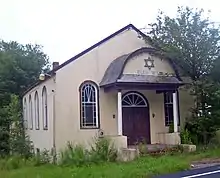
- Die Anshei Glen Wild Synagogue von 1923 in der nicht statuierten Siedlung Glen Wild
Literatur
- John Homer French: Gazetteer of the State of New York. R.P Smith, Syracuse NY 1860, S. 641 ff. (Textarchiv – Internet Archive).
- Franklin Benjamin Hough: Gazetteer of the State of New York. Band 2. A. Boyd, Albany NY 1873, S. 642 ff. (Textarchiv – Internet Archive).
Weblinks
Einzelnachweise
- Sullivan County im Geographic Names Information System des United States Geological Survey
- New York. (PDF) Listing of National Historic Landmarks by State, National Park Service; abgerufen am 21. Februar 2018.
- Suchmaske Datenbank. In: National Register Information System, National Park Service; abgerufen am 21. Februar 2018.
- Einwohnerzahl 1810–2010 laut Volkszählungsergebnissen
- Einwohnerdaten aus dem US-Census von 2010. In: American Factfinder
- Offizielle Daten. United States Board on Geographic Names
- Franklin Benjamin Hough: Gazetteer of the State of New York. Band 2. A. Boyd, Albany NY 1873, S. 645 ff.
Liste der Countys in New York
Albany |
Allegany |
Bronx |
Broome |
Cattaraugus |
Cayuga |
Chautauqua |
Chemung |
Chenango |
Clinton |
Columbia |
Cortland |
Delaware |
Dutchess |
Erie |
Essex |
Franklin |
Fulton |
Genesee |
Greene |
Hamilton |
Herkimer |
Jefferson |
Kings (Brooklyn) |
Lewis |
Livingston |
Madison |
Monroe |
Montgomery |
Nassau |
New York (Manhattan) |
Niagara |
Oneida |
Onondaga |
Ontario |
Orange |
Orleans |
Oswego |
Otsego |
Putnam |
Queens |
Rensselaer |
Richmond (Staten Island) |
Rockland |
Saratoga |
Schenectady |
Schoharie |
Schuyler |
Seneca |
St. Lawrence |
Steuben |
Suffolk |
Sullivan |
Tioga |
Tompkins |
Ulster |
Warren |
Washington |
Wayne |
Westchester |
Wyoming |
Yates