Suffolk County (New York)
Suffolk County[1] ist ein County im Bundesstaat New York, das etwa die östlichen zwei Drittel von Long Island einnimmt. Bei der Volkszählung im Jahr 2020 hatte das County 1.525.920 Einwohner[2] und eine Bevölkerungsdichte von 632 Einwohnern pro Quadratkilometer. Der Verwaltungssitz (County Seat) ist Riverhead.
| Verwaltung | |
|---|---|
| US-Bundesstaat: | New York |
| Verwaltungssitz: | Riverhead |
| Adresse des Verwaltungssitzes: |
3 East Pulteney Square Bath, NY 14810 |
| Gründung: | 1683 |
| Demographie | |
| Einwohner: | 1.525.920 (2020) |
| Bevölkerungsdichte: | 646,03 Einwohner/km2 |
| Geographie | |
| Fläche gesamt: | 6146 km² |
| Wasserfläche: | 3784 km² |
| Karte | |
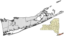
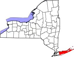 Karte von Suffolk County innerhalb von New York | |
| Website: www.co.suffolk.ny.us | |
Geschichte
Das County benannten die frühen Siedler der Provinz New York nach ihrer Heimat Suffolk. Die Gründung erfolgte am 1. November 1683.[3]

Elf Orte im County haben den Status einer National Historic Landmark.[4] 301 Bauwerke und Stätten des Countys sind insgesamt im National Register of Historic Places eingetragen (Stand 21. Februar 2018).[5]
Geographie
Das County hat eine Fläche von 6.146 Quadratkilometern, wovon 3.784 Quadratkilometer Wasserfläche sind. Im Westen grenzt es an das Nassau County.
Städte und Ortschaften
Das County ist wie die meisten New Yorker Countys in Towns unterteilt, in denen sich jeweils einige selbstverwaltete Dörfer (villages) und zahlreiche Weiler (unincorporated hamlets) befinden. Diese können jedoch auch zu mehreren towns gleichzeitig gehören.
- Town of Babylon (211.792 Einwohner)
- Villages: Amityville, Babylon, Lindenhurst
- Hamlets: Copiague, Deer Park, East Farmingdale, Gilgo-Oak Beach-Captree, North Amityville, North Babylon, North Lindenhurst, West Babylon, Wheatley Heights, Wyandanch
- Town of Brookhaven (448.248 Einwohner)
- Villages: Belle Terre, Bellport, Lake Grove, Old Field, Patchogue, Poquott, Port Jefferson, Shoreham
- Hamlets: Blue Point, Brookhaven, Calverton, Canaan Lake, Center Moriches, Centereach, Cherry Grove, Coram, Crystal Brook, Cupsogue Beach, Davis Park, East Moriches, East Patchogue, East Setauket, East Shoreham, Eastport, Farmingville, Fire Island Pines, Gordon Heights, Hagerman, Holbrook, Holtsville, Lake Ronkonkoma, Manorville, Mastic, Mastic Beach, Medford, Middle Island, Miller Place, Moriches, Mount Sinai, North Bellport, North Patchogue, Ocean Bay Park, Point of Woods, Port Jefferson Station, Ridge, Rocky Point, Ronkonkoma, Selden, Setauket, Shirley, Sound Beach, South Haven, Stony Brook, Strongs Neck, Terryville, Upton, Wading River, Water Island, West Manor, Yaphank
- Town of East Hampton (19.719 Einwohner)
- Villages: East Hampton, Sag Harbor
- Hamlets: Amagansett, Montauk, Springs, Wainscott
- Town of Huntington (195.289 Einwohner)
- Villages: Asharoken, Huntington Bay, Lloyd Harbor, Northport
- Hamlets: Centerport, Cold Spring Harbor, Commack, Dix Hills, East Northport, Eatons Neck, Elwood, Fort Salonga, Greenlawn, Halesite, Huntington, Huntington Station, Melville, South Huntington
- Town of Islip (322.612 Einwohner)
- Villages: Brightwaters, Islandia, Ocean Beach, Saltaire
- Hamlets: Bay Shore, Bayport, Baywood, Bohemia, Brentwood, Central Islip, East Islip, Great River, Hauppauge, Holbrook, Holtsville, Islip, Islip Terrace, Lake Ronkonkoma, North Bay Shore, North Great River, Oakdale, Ronkonkoma, Sayville, West Bay Shore, West Islip, West Sayville
- Town of Riverhead (27.680 Einwohner)
- Hamlets: Aquebogue, Baiting Hollow, Calverton, Jamesport, Northville, Riverhead, Wading River
- Town of Shelter Island (2.228 Einwohner)
- Village: Dering Harbor
- Hamlet: Shelter Island Heights
- Town of Smithtown (115.715 Einwohner)
- Villages: Head of the Harbor, Nissequogue, Village of the Branch
- Hamlets: Commack, Fort Salonga, Kings Park, Lake Ronkonkoma, Nesconset, Smithtown, St. James
- Town of Southampton (54.712 Einwohner)
- Villages: North Haven, Quogue, Sag Harbor, Southampton, Westhampton Beach, Westhampton Dunes
- Hamlets: Bridgehampton, Eastport, East Quogue, Flanders, Hampton Bays, Northampton, North Sea, Noyack, Quioque, Remsenburg, Riverside, Sagaponack, Shinnecock Hills, Southampton, Speonk, Tuckahoe, Water Mill, Westhampton
- Town of Southold (20.599 Einwohner)
- Village: Greenport
- Hamlets: Cutchogue, East Marion, Fishers Island, Laurel, Mattituck, Orient, New Suffolk, Peconic, Southold
Parks
- Heckscher State Park nahe East Islip.
- Sunken Meadow State Park nahe Smithtown.
Weblinks
Einzelnachweise
- Suffolk County (Englisch) In: Geographic Names Information System. United States Geological Survey. Abgerufen am 14. April 2018.
- Quickfacts: Suffolk County (Englisch)
- Charles Curry Aiken, Joseph Nathan Kane: The American Counties: Origins of County Names, Dates of Creation, Area, and Population Data, 1950–2010. 6. Auflage. Scarecrow Press, Lanham 2013, ISBN 978-0-8108-8762-6, S. 292.
- Listing of National Historic Landmarks by State: New York. National Park Service, abgerufen am 21. Februar 2018.
- Suchmaske Datenbank im National Register Information System. National Park Service, abgerufen am 21. Februar 2018.
Liste der Countys in New York
Albany |
Allegany |
Bronx |
Broome |
Cattaraugus |
Cayuga |
Chautauqua |
Chemung |
Chenango |
Clinton |
Columbia |
Cortland |
Delaware |
Dutchess |
Erie |
Essex |
Franklin |
Fulton |
Genesee |
Greene |
Hamilton |
Herkimer |
Jefferson |
Kings (Brooklyn) |
Lewis |
Livingston |
Madison |
Monroe |
Montgomery |
Nassau |
New York (Manhattan) |
Niagara |
Oneida |
Onondaga |
Ontario |
Orange |
Orleans |
Oswego |
Otsego |
Putnam |
Queens |
Rensselaer |
Richmond (Staten Island) |
Rockland |
Saratoga |
Schenectady |
Schoharie |
Schuyler |
Seneca |
St. Lawrence |
Steuben |
Suffolk |
Sullivan |
Tioga |
Tompkins |
Ulster |
Warren |
Washington |
Wayne |
Westchester |
Wyoming |
Yates