Tompkins County
Tompkins County[1] ist ein County im Bundesstaat New York der Vereinigten Staaten. Bei der Volkszählung im Jahr 2010 hatte das County 101.564 Einwohner und eine Bevölkerungsdichte von 82,6 Einwohner pro Quadratkilometer. Der Verwaltungssitz (County Seat) ist Ithaca. Ithaca beheimatet die Cornell University.
 Tompkins County Courthouse | |
| Verwaltung | |
|---|---|
| US-Bundesstaat: | New York |
| Verwaltungssitz: | Ithaca |
| Gründung: | 7. April 1817 |
| Gebildet aus: | Cayuga County Seneca County |
| Vorwahl: | 001 607 |
| Demographie | |
| Einwohner: | 101.564 (2010) |
| Bevölkerungsdichte: | 82,62 Einwohner/km2 |
| Geographie | |
| Fläche gesamt: | 1.273,1 km² |
| Wasserfläche: | 43,8 km² |
| Karte | |
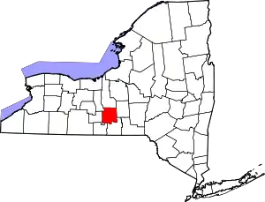 Karte von Tompkins County innerhalb von New York | |
| Website: www.co.tompkins.ny.us | |
Geographie
Das County hat eine Fläche von 1.273,1 Quadratkilometern, wovon 43,8 Quadratkilometer Wasserfläche sind.
.svg.png.webp)
Geschichte
Das County hat seinen Namen nach Daniel D. Tompkins, einem früheren Gouverneur New Yorks und Vizepräsidenten der Vereinigten Staaten. Es wurde am 7. April 1817 gegründet.[2]
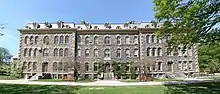
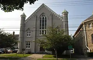
Ein Ort im County hat den Status einer National Historic Landmark, die Morrill Hall auf dem Campus der Cornell University.[3] 58 Bauwerke und Stätten des Countys sind insgesamt im National Register of Historic Places eingetragen (Stand 21. Februar 2018).[4]
Einwohnerentwicklung
| Jahr | 1800 | 1810 | 1820 | 1830 | 1840 | 1850 | 1860 | 1870 | 1880 | 1890 |
|---|---|---|---|---|---|---|---|---|---|---|
| Einwohner | – | – | 20.681 | 35.545 | 37.948 | 38.746 | 31.409 | 33.178 | 34.445 | 32.923 |
| Jahr | 1900 | 1910 | 1920 | 1930 | 1940 | 1950 | 1960 | 1970 | 1980 | 1990 |
| Einwohner | 33.830 | 33.647 | 35.285 | 41.490 | 42.340 | 59.122 | 66.164 | 77.064 | 87.085 | 94.097 |
| Jahr | 2000 | 2010 | 2020 | 2030 | 2040 | 2050 | 2060 | 2070 | 2080 | 2090 |
| Einwohner | 96.501 | 101.793 |
Städte und Ortschaften
Zusätzlich zu den unten angeführten selbständigen Gemeinden gibt es im Tompkins County mehrere villages.
| Ortschaft | Status | Einwohner (2010)[6] | Gesamte Fläche [km²][7] | Landfläche [km²][7] | Bevölkerungsdichte [Einwohner / km²] | Gründung[8] | Besonderheit |
|---|---|---|---|---|---|---|---|
| Caroline | town | 3.282 | 142,2 | 141,8 | 23,1 | 22. Feb. 1811 | |
| Danby | town | 3.329 | 139,3 | 138,7 | 24,0 | 22. Feb. 1811 | |
| Dryden | town | 14.435 | 244,3 | 242,5 | 59,5 | 22. Feb. 1803 | |
| Enfield | town | 3.512 | 95,4 | 95,1 | 36,9 | 16. März 1821 | |
| Groton | town | 5.950 | 128,3 | 128,0 | 46,5 | 7. Apr. 1817 | Gründungsname: Division; umbenannt am 13. März 1818 |
| Ithaca City | city | 30.014 | 15,7 | 14,0 | 2143,9 | 2. Apr. 1821 | County Seat; Gründung als Village; zur City ernannt 1888 |
| Ithaca Town | town | 19.930 | 78,4 | 75,0 | 265,7 | 16. März 1821 | |
| Lansing | town | 11.033 | 181,1 | 156,7 | 70,4 | 7. Apr. 1817 | |
| Newfield | town | 5.179 | 152,7 | 152,4 | 34,0 | 22. Feb. 1811 | Gründungsname: Cayuta; umbenannt am 29. März 1822 |
| Ulysses | town | 4.900 | 95,6 | 85,2 | 57,5 | 5. März 1799 |
Literatur
- John Homer French: Gazetteer of the State of New York. R.P Smith, Syracuse NY 1860, S. 654 ff. (Textarchiv – Internet Archive).
- Franklin Benjamin Hough: Gazetteer of the State of New York. Band 2. A. Boyd, Albany NY 1873, S. 655 ff. (Textarchiv – Internet Archive).
Weblinks
Einzelnachweise
- Tompkins County (Englisch) In: Geographic Names Information System. United States Geological Survey. Abgerufen am 22. Februar 2011.
- Charles Curry Aiken, Joseph Nathan Kane: The American Counties: Origins of County Names, Dates of Creation, Area, and Population Data, 1950–2010. 6. Auflage. Scarecrow Press, Lanham 2013, ISBN 978-0-8108-8762-6, S. 425.
- New York. (PDF) Listing of National Historic Landmarks by State, National Park Service; abgerufen am 21. Februar 2018.
- Suchmaske Datenbank. National Register Information System, National Park Service; abgerufen am 21. Februar 2018.
- Einwohnerzahl 1820–2010 laut Volkszählungsergebnissen
- Einwohnerdaten aus dem US-Census von 2010. In: American Factfinder
- Offizielle Daten. United States Board on Geographic Names
- Franklin Benjamin Hough: Gazetteer of the State of New York. Band 2. A. Boyd, Albany NY 1873.
Liste der Countys in New York
Albany |
Allegany |
Bronx |
Broome |
Cattaraugus |
Cayuga |
Chautauqua |
Chemung |
Chenango |
Clinton |
Columbia |
Cortland |
Delaware |
Dutchess |
Erie |
Essex |
Franklin |
Fulton |
Genesee |
Greene |
Hamilton |
Herkimer |
Jefferson |
Kings (Brooklyn) |
Lewis |
Livingston |
Madison |
Monroe |
Montgomery |
Nassau |
New York (Manhattan) |
Niagara |
Oneida |
Onondaga |
Ontario |
Orange |
Orleans |
Oswego |
Otsego |
Putnam |
Queens |
Rensselaer |
Richmond (Staten Island) |
Rockland |
Saratoga |
Schenectady |
Schoharie |
Schuyler |
Seneca |
St. Lawrence |
Steuben |
Suffolk |
Sullivan |
Tioga |
Tompkins |
Ulster |
Warren |
Washington |
Wayne |
Westchester |
Wyoming |
Yates